Mountain range, region / State
Kavkaz / Georgia
Season
Summer
01. 08. - 05. 08. 2019
Difficulty
4 / 5
Elevation
↑ 4287 m
↓ 3594 m
Length
56.0 km
5 days
Altitude
max. 3138 m n.m.
min. 1393 m n.m.
Tourist map of Svanetia in the Caucasus
Tips for hikes in the country Georgia
Partial crossing of the Borjomi Mountains in Georgia
Crossing hike from Mestia to Ushguli (Svanetia crossing)
Starting point
Description of the hike
1. day
In the morning we leave Mestia, where we were staying. The road is easy to find and well marked. It alternates between woods and meadows, so it passes pleasantly. Soon we are in a saddle above the village of Zardlaši, where there is a beautiful view and a camping site. There are quite a few tourists here too. But they only come with us as far as the village of Zardlaši and the road is empty.
We pass through smaller villages - in each of them you could buy something good if they were not closed. In the village of Cholaši there is a big spring in the village square where it is good to get water. The Mulchura River is crossed by a bridge just after Cholaši and at the village of Chvabiani (we're just here for lunch) we turn up the slope to the winter resort.
Continue straight up a short distance to the left of the stream, which, although very poorly accessed, has clear water and a lovely place to sleep. Further on, the path is easy to follow but steep and poorly marked. In addition, there are often confusing turns off the trail, so one has to keep a constant eye on one's bearings. We sleep just below the slope on a grassy patch by the trail. There is a small stream here.
First day's dates: 18 km; 1,250 m up, 400 m down.
2. day
We will walk the rest of the trail to the lower cable car station. It doesn't leave until around 10am, so we walk up the path next to the ski slope. At the turn-off to Adis about halfway up the cable car, you can choose your route:
The more difficult (but prospectively more interesting) trail climbs a few hundred more vertical metres up the slope and then continues along the traverse of the mountain meadows. The easier trail cuts straight off here and partly plunges into a nice forest.
Both trails are well marked, passable and meet just before the village of Adisi, where we arrive just in time for lunch. There are several guesthouses, a small market and a couple of taverns. Although the village is small and partly depopulated, it has its own special charm. We continue on more or less following the contour of the Adishala river valley.
The road ends at the ford of the river itself. This can only be forded in the morning when the flow of the glacial river is at its weakest. During the day it is also possible to be ferried across the river on horseback for a fee, but in the afternoon the current is too strong even for that. Fortunately, there is a very nice place to sleep just at the ford (in a small draw), which we will take advantage of.
Dates of the second day: 13 km; 500 m up, 500 m down.
3. day
We'll cross the river early in the morning. It's icy as hell, fast, but the water's not even knee-deep. We have breakfast on the other bank and continue to the Chchunderi saddle ( 2720 m above sea level).
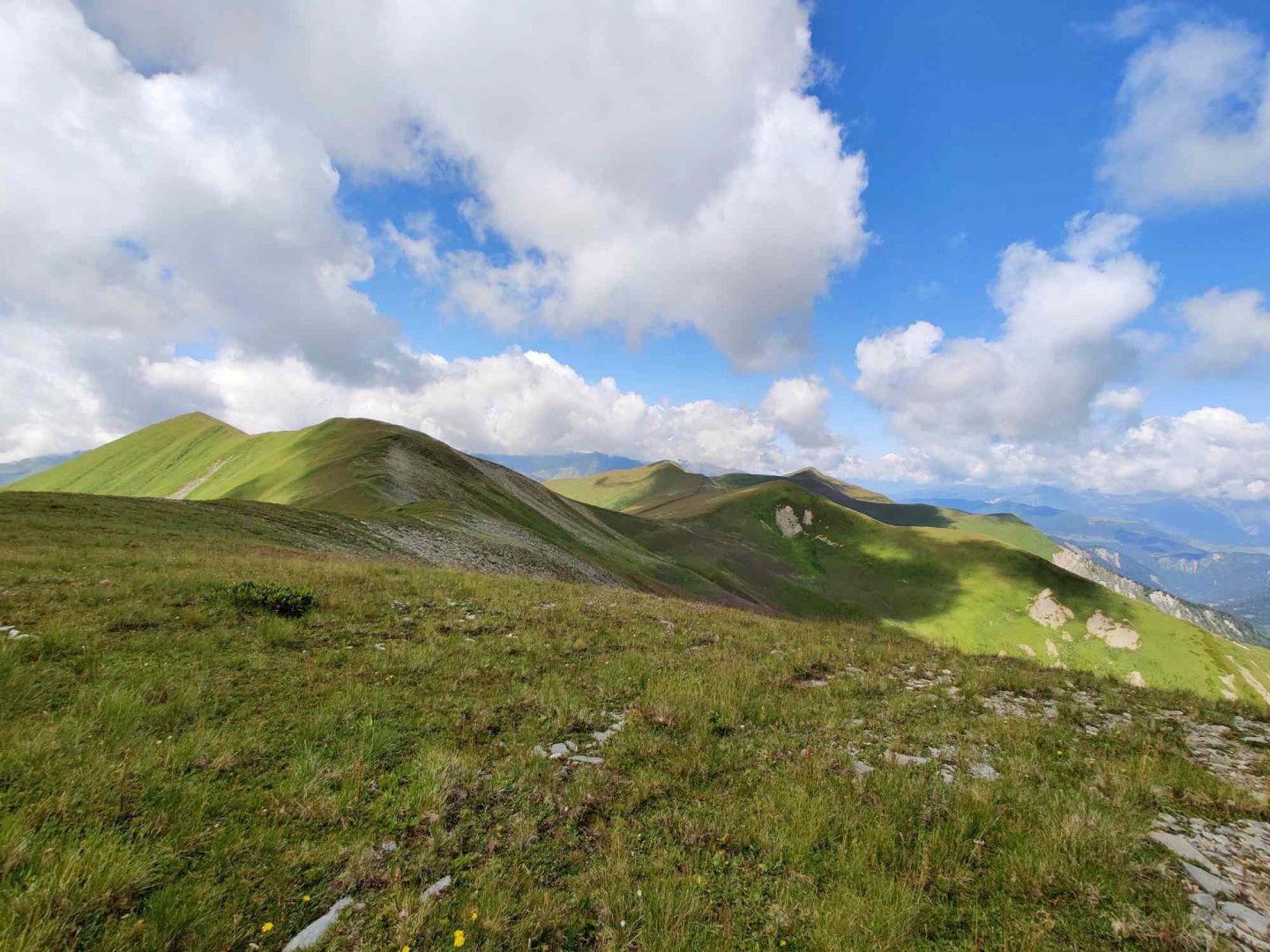
We leave our luggage in the saddle and lightly climb the peak of Chchunderi (3 036 m above sea level), from where we have a wonderful view of the Tetnuldi massif (4 858 m above sea level), the Adishi glacier and the surrounding meadows.
We descend to the saddle by the same route, have lunch and again descend steeply towards the Chaldeshala River. There is a large number of people on the road and a large spring a little above the river (otherwise there was no water during the day). But down by the river the crowds break off and descend to the village of Chalde, which is also the official crossing route.
We want to use the unmarked trail over the Lagem saddle (3,000m) to the Enguri river valley and enjoy the mountains a bit more. Fortunately, the trail has been freshly cut - otherwise it would be impossible to find it, as practically no one walks on it.
The trail is also very steep and in wet weather the Lagem saddle would be impassable. However, the trail has already appeared on the current paper map (2020), so it can be assumed that it has already been marked and is being maintained. In any case, we will continue on it.
With difficulty (the path gets completely lost for a bit) we find an old bridge over the Chladeshala River and use it. Otherwise it would not be possible, because the river is very strong and crossing it would be practically impossible.
From the river we continue up the already cut trail and just beyond the forest border there is a sleeping area. It is very nice here and there is even a stream with water a short distance away. It is very difficult to descend to it - the best way is to continue about a kilometer further along the hiking trail and it will take you to it.
Date of the third day: 10 km; 900 m up, 750 m down.
4. day
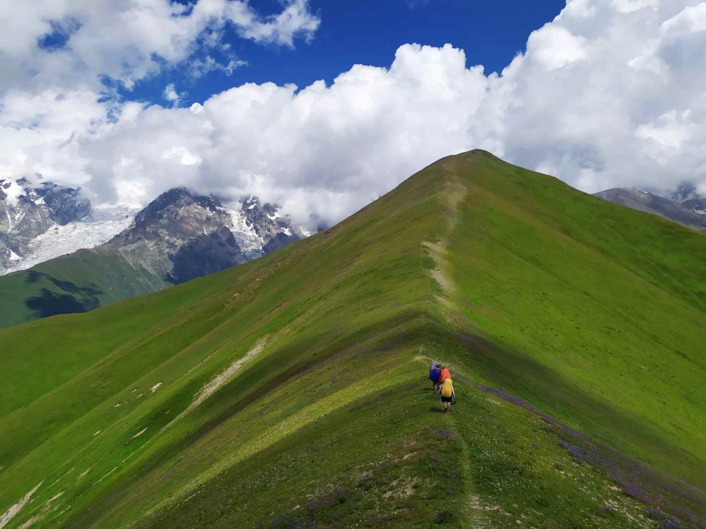
In the morning, continue along the cut trail to the ford of the aforementioned creek, after which you will come upon a sharp grassy ridge. Here begins a long climb straight up to the Lagem saddle. There is no problem with orientation.
However, the trail wades through rhododendrons and is quite steep. About halfway up the slope the rhododendrons turn into grass and the profile rises even more, so that even in dry conditions we have a lot of trouble climbing the saddle. No water anywhere.
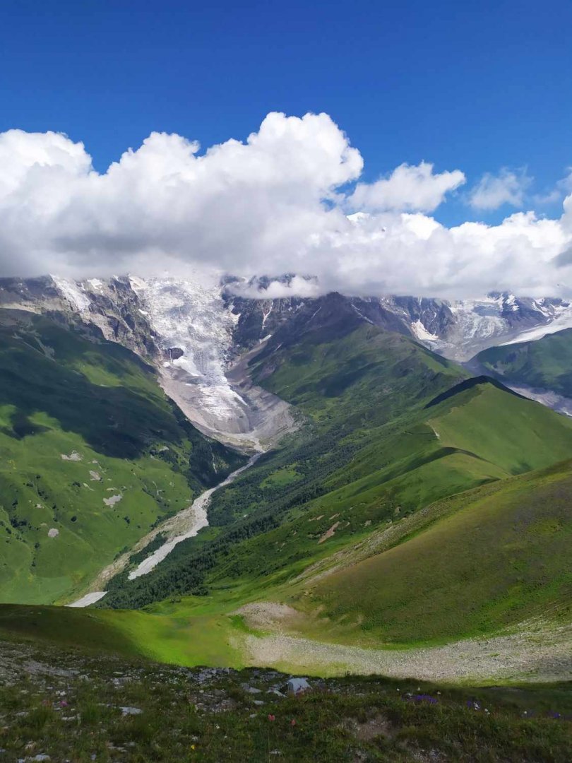
We have lunch in the saddle and head north to the unnamed peak (3,142m), whose ridge we walk along to above the Chalde glacier. Very nice views. We return to the saddle and head down into the other valley. The way down is not as steep as the way up, but for the most part it disappears completely.
At the beginning the whole slope traverses southwards. About halfway up, two chutes must be crossed. There is a little bit of divination in the process, but it is worth continuing to traverse intuitively (not dodging down the trough) and the trail will reappear. The rhododendrons turn into a dense and very pretty meadow.
It's straight down, and even if the trail gets lost here and there, just keep going. You will come above a larger stream, which the path slowly traverses down to. From the stream, the orientation is no longer problematic and it just descends to the Inguri River. There is plenty of water everywhere on this slope. The road is even heavily waterlogged in places.
We climb down in the valley and come across a very nice meadow by the river where we pitch our tents. The Inguri River flows out of a glacier on the slopes of Mount Shkhar (5,201 m .a.s.l.), which is the highest mountain in Georgia. This makes the valley busy.
A jeep with Japanese tourists occasionally passes along the way (they all took pictures of us as wild animals), cattle graze and packs of stray dogs run around. Two of them even liked us so much that they spent a rainy night with us in our tents. In the evening, however, there is not a foot anywhere and it is quiet. There are also very nice places to sleep in the meadows above the village of Ushguli 3 kilometres away.
Dates of the fourth day: 15 km; 800 m up, 1050 m down.
5. day
In the morning we will just walk along the road in front of Ushguli. We're guarded by our favourite pair of stray dogs. We leave the valley at a nice monastery (which we quickly see) and an even nicer pub (which we sink into for a few hours). From the terrace there is a wonderful view of the whole Šchara massif.
Some of us rented horses and took a ride all the way down the valley to the glacier. In the afternoon we just descend into the town of Ushguli, find a shuttle almost immediately and take a rather adrenaline-filled ride back to Mestia. The fare is very inflated on this popular tourist road - count on 30 to 50 Lari per person.
Day 5 dates: 4 km; 50 m up, 150 m down.
Difficulty
Water availability
There's plenty of water all the time. Every day we ended up in a little valley where there was always a stream with water, so you don't have to overdo it with water supplies for the trip. We didn't filter the water, but it wasn't exactly crystal clear either.
Sleeping options
We slept under a tent and it was never a problem to find a flat grassy patch. In the villages along the way (Svabiani, Adisi, ...) it is possible to find a guesthouse and for money sleep under a roof. But the villages are few along the way and the route is long. In Mestia and Ushguli, however, it is not a problem to find accommodation both in a guesthouse and under a tent.
Danger
Along the way (as in the rest of Georgia), the invasive plant Bolshevik magnificent is often found. This is dangerous in contact with the skin (for example, if someone falls into it) and it's a good idea to know first aid for this.
The 4th day of the crossing in particular is potentially dangerous due to steep slopes and poor signage. Otherwise the route is relatively safe. There are a large number of stray dogs in the Inguri River valley (between Ushguli and Mount Shkara). However, none of them attacked us, they just fight with each other.
Food
We had our own food for the whole 5 days. We were able to eat and do a little shopping on the 2nd day in the village of Adishi, but due to its size and remoteness I wouldn't rely on it too much. However, it is of course possible to do some major shopping in Mestia.
Attractions
Although this corner of the Caucasus is very famous, popular and beautiful, it is not protected by any nature park. Fortunately, it is not yet unspoilt and only the town of Mestia is growing unstoppably.
The biggest attraction on the route is definitely the village of Ushguli, part of which is a UNESCO World Heritage Site and is said to be the highest village in Europe (2,200m above sea level) - it depends on the interpretation of the border between Europe and Asia.
The entire crossing passes through the historic territory of Svaneti, which is known in particular for its typical defensive towers, which are also said to have served as a shelter for those involved in the blood feud. These towers can be visited - most of them are still inhabited by people. Svanetia also has quite an interesting and rich history, which I recommend studying before your trip.
Photos