Mountain range, region / State
/ Montenegro
Season
Summer
30. 06. 2019
Difficulty
3 / 5
Elevation
↑ 1698 m
↓ 1698 m
Length
17.9 km
10 hours
Altitude
max. 2535 m n.m.
min. 1025 m n.m.
Tourist map of the ascent to the top of Zla Kolata
Tips for hikes in the mountain range
Climb to the highest mountain of Montenegro - Zla Kolata
The route to the highest mountain in Montenegro and Albania - Zla Kolata 2 534 m above sea level.
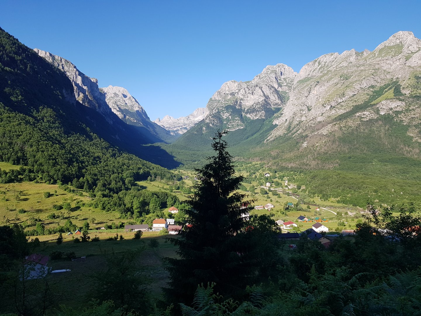
Starting point
The tour starts in the village of Vusanje. There is an asphalt road leading to the village - no problem to get there by car. There is a place to pitch your tent / park your car in the village down by the river Grlja. The bus only goes to the town of Gusinje from where it is about 7 km to Vusanje (you can hitchhike). But there are plenty of "guesthouses" in Vusanje - many of them have fb pages where you can stay (even in a tent in the garden) and they will drive down to Gusinje for you by appointment.
Description of the hike
We leave a little after 7am. The sign from the village of Vusanje is well made. Even so, sometimes you have to check it with the GPS, so you don't take a wrong turn towards a farm in the valley) and leads us along a forest road.
After quite a long way, the road leads out to meadows near Katun, where sheep cheese (6 Euro per kg) and other goodies are sold. Surprisingly, the whole path is littered with annoying mosquitoes - we didn't encounter them elsewhere in Prokletije.
There is a nice spring above the katun (but it's not far) which, according to the map, is also the last source of water. Here follows a series of climbs over about 4 terraces. Sometimes you have to climb and the path gets lost, but it is not a problem to find it right away.
According to the map, there is a fork just above the spring and the path to the grassy ridges above Gusinje should turn here (maybe there is a trail that turns here). In reality, however, the fork and the marked path is only at the Bora place 1-2 terraces higher.
There are nice flat and grassy places to sleep on those terraces, but the water is only at the last spring above the katun, and there are still plenty of mosquitoes. The terraces end at the Ice Cave, from where you can already see the summit.
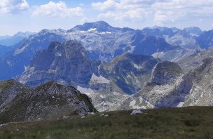
The meadow is traversed under the famous majesty of Dobre Kolata 2 525 m above sea level to the saddle on the border with Albania. The saddle is not even reached, the trail turns left and cuts into the slope of Dobre Kolata, where the trail goes through gravel and is a bit exposed. Here the trail bypasses a small snowfield with a rock above it and it is a challenge not to lose the trail marker. After that, it's just a scramble up the 2,400m saddle between Dobra and Zla Kolata.
There is plenty of snow around, but none on the road yet. As unpromising as the summit looks from below, there is a meadow path from the saddle to the top of Zlá Kolata 2 534 m above sea level and there are no exposed sections. In places there is snow and at the very end there is about 20m of climbing, but nothing dangerous.
There is plenty of space at the top and beautiful views of the Valbona valley, Maju e Jezercës 2 694 m above sea level and the whole of Montenegro and Albanian Prokletije. The journey to the top took a fair 5 hours of walking.
The way down is the same and a bit faster. We arrive destroyed in a total time of 10 hours, it's really far. We met only one person on the way and the weather was beautiful (too much, we are burnt to a crisp).
Route data: 18,5 km; 1 500 m up, 1 500 m down
Difficulty
The trail is relatively well marked (I still recommend mapy.cz with GPS) and well-traveled. At the beginning it leads along a forest path, then along a meadow and at the end through scree, including slightly climbable sections. None of the sections are secured, but it is not dangerously exposed. There were (late June) thick snowfields below the summit which we had to walk around.
Water availability
Approximately in the middle of the path (above the shepherd's catun) there is a strong spring in accordance with the sign in mapy.cz and it should be possible to rely on it. There is not much water elsewhere. On the ascent it was enough for us to have 2 litres of water per person.
Sleeping options
We slept in the "guesthouse" Alpina. But the village of Vusanje is full of these guesthouses and you just have to arrive there and choose one. Compared to the rest of Montenegro, the local guesthouses are quite expensive (we paid 10 Euro per tent per night) and the facilities are not very good. You can also use the aforementioned beach by the river to sleep.
If you have a car, I strongly recommend the valley next to Grbaje (Grebaje) for sleeping. There is an "Eko-Katun Grbaje" with an excellent restaurant, where you can sleep for cheap in tents in the garden or in new cabins. Alternatively, you can sleep for free in the meadows behind it - with the beautiful massifs of Volusnica and Karanfili overhead. From the Grbaje valley it's about 15 km by car to Vusanje, and it's no problem to drive down there for the Zla Kolata turnaround.
Attractions
Although the villages of Vusanje and its surroundings are located in Montenegro, they are mainly inhabited by Albanians. The locals speak both Albanian and Serbian (Montenegrin), and unlike the "Albanians of Albania", you won't alienate them by using Serbian - fortunately they don't deal with politics.
Many of them also boast about their English. However, their level of English is mostly very poor and using English made communication with the locals paradoxically difficult. Just outside the village of Vusanje there is a beautiful spring called Oko Skakavice, which is well worth a visit.
Near the village of Gusinje there is another powerful spring - Alipashina Izvori. The frequency of these strong springs is due, among other things, to the fact that the Prokletije mountains are among the rainiest places in Europe. The peak of Zla Kolata is in fact the highest peak of Montenegro. However, due to its remoteness, Montenegro officially lists Bobotov Kuk (the highest peak of Durmitor), a few meters lower, as its highest peak.
The whole area lies in the Sandžak region, which is inhabited mainly by Muslims. The Prokletije mountains are also the last European place that was until recently governed by Albanian customary law (Kanun) and where blood feuds can still be found today. As a result, interesting mosques and 'Kula' (defensive towers for those involved in blood feuds) can be visited (especially in the town of Plav). Despite the potentially explosive political situation (poverty, proximity to Kosovo, ethnic and religious mix), the region was fortunately not affected by the civil wars of the 1990s. On the contrary, the locals are very peaceful and hospitable, which, unfortunately, cannot be said of neighbouring countries in general. Overall, it is very safe here.
Photos