Mountain range, region / State
Poloniny / Ukraine
Season
Summer
03. 09. - 04. 09. 2018
Difficulty
3 / 5
Elevation
↑ 1385 m
↓ 1261 m
Length
23.0 km
2 days
Altitude
max. 1684 m n.m.
min. 553 m n.m.
Tourist map of the Poloniny Mountains in Ukraine
Two-day hike from Koločava through the Piškoňa Poloniny
Starting point
The trailhead is in the village of Koločava. The trail starts naturally in the centre of the village, where there is a school, the Ivan Olbracht Museum and many other monuments and tourist attractions.
However, those who want to save some kilometres at the beginning can start from the road about halfway between the villages of Nehrovec and Koločava - see the map. The village can be reached quickly and easily by taxi or minibus. For example, from the village of Volovec, where the train from Mukachevo goes, or from the village of Mizhorje, through which buses from Chust go.
There is also a regular bus to Kolochava about twice a day. Travelling by car is also possible (at least the road from Mizhorje is asphalt, but the others probably are too), but I didn't see any suitable parking in the village. However, there is no convenient water source in the village, nor is there a major shop, so I recommend equipping yourself in a larger town on the way (like Volovec, or Mizhorje).
Description of the hike
1. day
Around noon we arrive by minibus from Volovec to Koločava and go straight to the local pub Chetnicka Station. Although many a tourist book warned against it, our thirst is so great that we each take a sip. Even this is enough to give us such severe intestinal problems 2 days later that they reliably exclude us from further wandering for several days. But otherwise the pub is fine, the prices are reasonable and the food looked very good.
Inside there is also an interesting exhibition about one of the summer camps of Jaroslav Foglar's scout troop, which took place here during the First Republic. We also see the centre of Koločava, which is full of monuments commemorating the story of Nikola Šuhaj and his creator Ivan Olbracht.
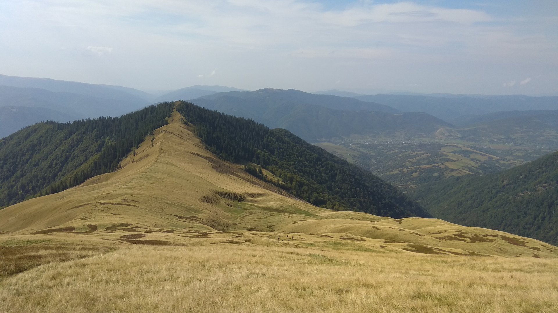
We take the road through the village back to where we came from. After about 3 km we turn off along a marked trail to the beautiful pastures above the village and begin to climb. Soon we enter the forest, where the altitude meters gain quite quickly and after a few hours we emerge on the beautiful Barvinok peak (1 461 m above sea level).
Here the poloniny (mountain meadows typical for this part of the Carpathians) begin and a wonderful view of the whole area opens up - we can see the valley of the Terebly river, the whole Piskoňa poloniny and part of Horhan. After the summit we descend to the first saddle, where we turn a little to the left to 2 small lakes with a flat place to sleep.
Date of the first day: 9 km; 900 m up, 100 m down.
2. day
It was raining at night and in the morning, so we sleep peacefully, dry our tents and leave at 11 o'clock. We continue along the marked trail below the Horb peak (1 687 m) to the saddle in front of the Nehrovec peak (1709 m), where there is also a small lake and a convenient place to sleep.
We are on Nehrovec once or twice and again enjoy a beautiful view of the neighbouring Horhan ridges. The trail continues along the ridge to the top of Velika Hropa (1 667 m above sea level). From the top you can see the cross, which is located at the end of the whole ridge - we continue to it. Behind this cross, the descent down the forest path begins.
The whole ridge is not very long (about 7 km), nor too high, but it is very diverse. The Poloniny at Barvinok looks completely different from the Poloniny below Nehrovec, which in turn is completely different from the Poloniny at Velika Hropa. In contrast, the rocky slopes of the Horhany rise with the densely wooded valleys of the local rivers.
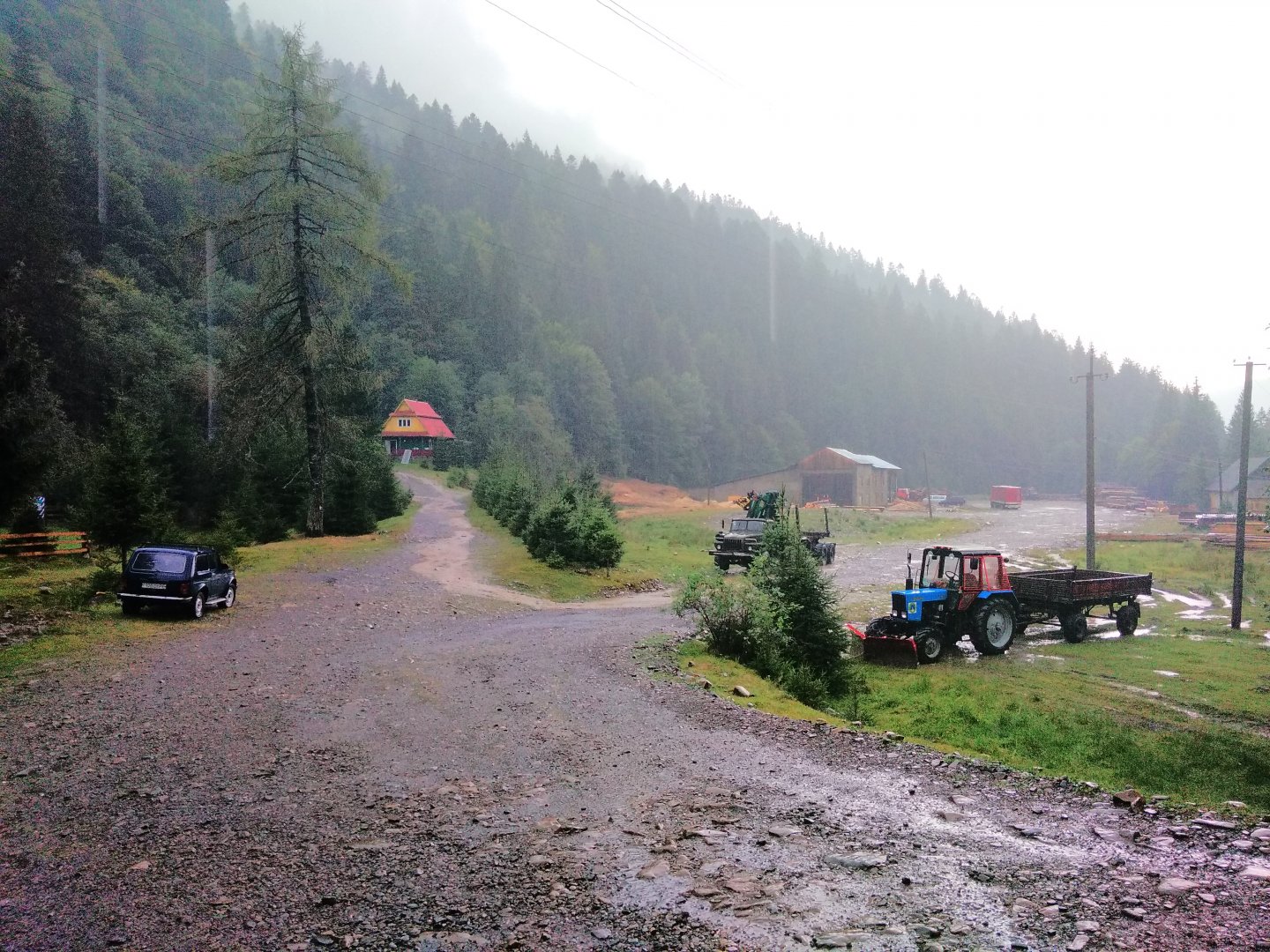
On the descent we meet several small trickles of water, but I would be more careful with water here. There is a marked and strong drinking water spring at the very end of the descent - at the sawmill on the Terebla River. About 200m down the main road past the sawmill is what looks like a campsite and guesthouse (both were abandoned in September). As it started to rain heavily again (the rains here are really fair), we slept in comfort on the porch of the guesthouse under the roof.
In the morning we hitchhiked on the main road to Mižhorje. There is no other way to get there. There is not much traffic here, so you have to take into account that hitchhiking will take some time.
Dates of the second day: 14 km; 500 m up, 1200 m down.
Difficulty
The trek is not technically demanding. The trails lead along trodden meadow paths and at lower elevations along forest paths. The steep climb is only just after the village of Koločava and even after rain it was manageable. The signposting is absolutely sufficient and we did not get lost anywhere.
Water availability
There was no water on the polonina itself (we went in September). At lower elevations you can come across smaller trickles. However, I recommend filtering the water if necessary - there are a lot of cattle and old forestry equipment everywhere. The big spring is at the very end of the trail at the sawmill on the Tereble River.
Sleeping options
The ridge is all grass, so you can sleep practically anywhere. At the end of the hike, you can sleep on the aforementioned campsite, or there is a nice grassy area near the sawmill.
Danger
The biggest danger turned out to be beer from the Chetnicka Station pub in Kolochava. Bears are not usually found on this particular polonina, but there are said to be quite a few on the surrounding slopes.
Attractions
The most interesting point of the crossing is undoubtedly the village of Koločava, associated with the story of the robber Nikola Šuhaj. On any website about the Ukrainian Carpathians you can find tons of interesting information about this village and the story itself.
The whole route goes through the Sinevir National Park. A popular destination in this park is Lake Sinevir. You can easily get to it from the end of this crossing (at the sawmill) if you hitch a ride in a car going towards the village of Siněvirska Poljana. The lake is located about 1.5 km behind it.
Photos