Mountain range, region / State
Gunung Rinjani / Indonesia
Season
Summer
26. 07. - 28. 07. 2013
Difficulty
4 / 5
Elevation
↑ 4199 m
↓ 3802 m
Length
33.8 km
3 days
Altitude
max. 3726 m n.m.
min. 597 m n.m.
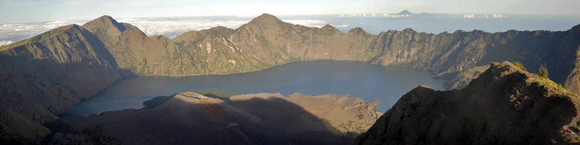
Three-day trek in Indonesia on the island of Lombok - Gunung Rinjani volcano 3 726 m above sea level.
Starting point
Gunung Rinjani volcano is located on the island of Lombok, southeast of Bali. We started the trek in the town of Senaru, where we arrived from Mataram. We had already arranged this trek from the Gili Islands, so our guide picked us up in Mataram and drove us to Senaru (here we left most of the things we had with us when travelling in Indonesia with our guide and just took the essentials for the trek - clothes, cameras, creams, sleeping bags, energy bars - food, drinks and tents were included).
Senaru is one of the two starting points of the trek to the top of Gunung Rinjani (the other starting point is Sembalun Lawang - where we ended the trek). At the southern end of Senaru is the embarkation point for the trek. You can recognize it very easily, there is a gate with a big sign saying "Taman Nasional Gunung Rinjani", "Pintu Senaru" - that is Gunung Rinjani National Park, enter through the gate from Senaru.
Description of the hike
1. day
From the entrance to the Gunung Rinjani National Park (about 600 m above sea level) the path leads through the forest in a northerly direction (photo). There are not many other roads to take a wrong turn on. The journey through the rainforest is an experience for a European, mainly due to the high humidity. Personally, I wrung a fair decade's worth of sweat out of my shirt after two hours of walking, and I wasn't alone.
In the high season (we went in July, which is the ideal time for climbing) you will never be alone on this trek. We also went at the same time with several other groups of tourists. On the way from the national park gate, you will pass two shelter sites, referred to as POS I and POS II, where you can refresh yourself in peace.
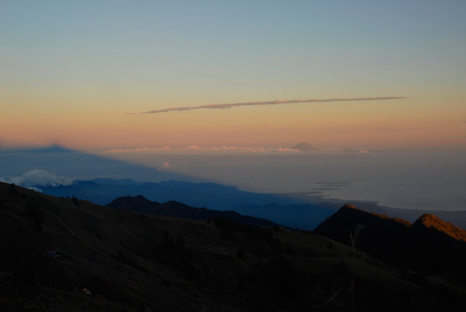
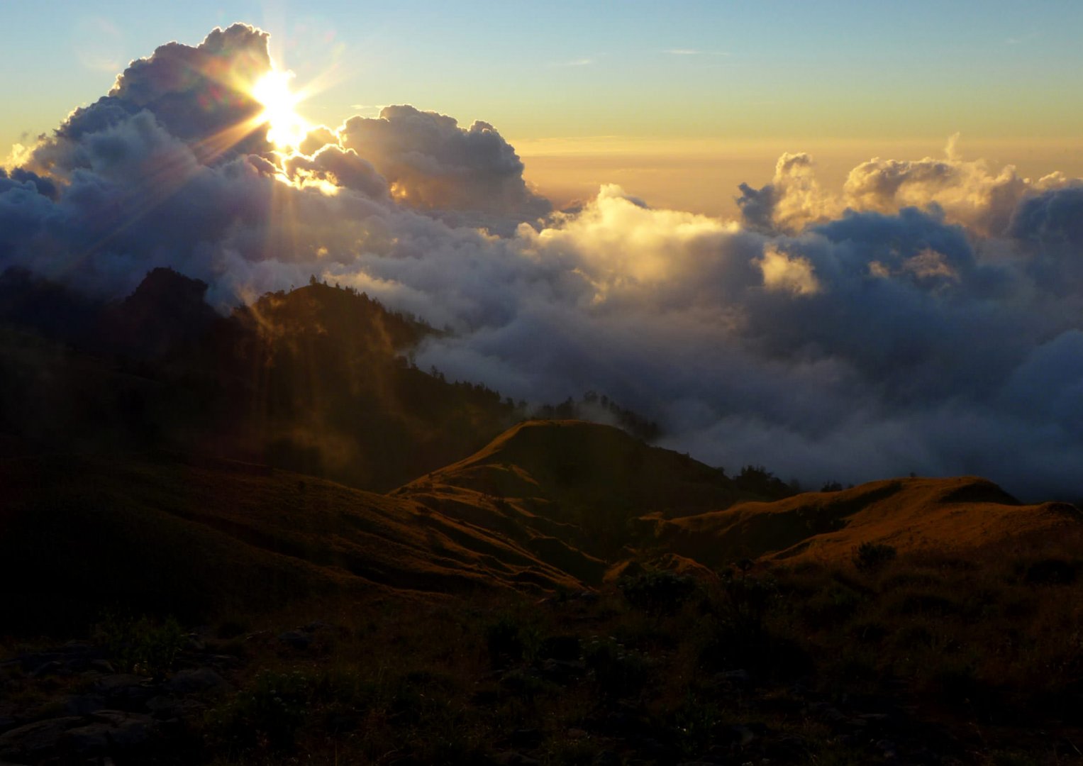
After about five hours of walking in the rainforest at an altitude of 2,200 m above sea level, the forest ends and turns only into low grass with stones. After another hour or so of walking you will reach the edge of the volcano crater, where there are several tent sites. Here the porters set up our tent and cooked us dinner. From the rim of the crater there are beautiful views to the caldera of the volcano and to the summit of Gunung Rinjani itself (photo).
2. day
The next day, after breakfast, we continued from the rim of the crater steeply down to Segara Anak Lake. The path is secured with metal railings at the beginning, but later it is not so steep. It takes about 2 hours to get to Lake Anak. It is possible to swim in the lake. We had a small snack at the lake and headed up the northeast valley to the Aik Kalak hot springs (about 20 min from Anak Lake). I recommend bathing in the hot springs before the next trip, it's a nice relaxation (photo).
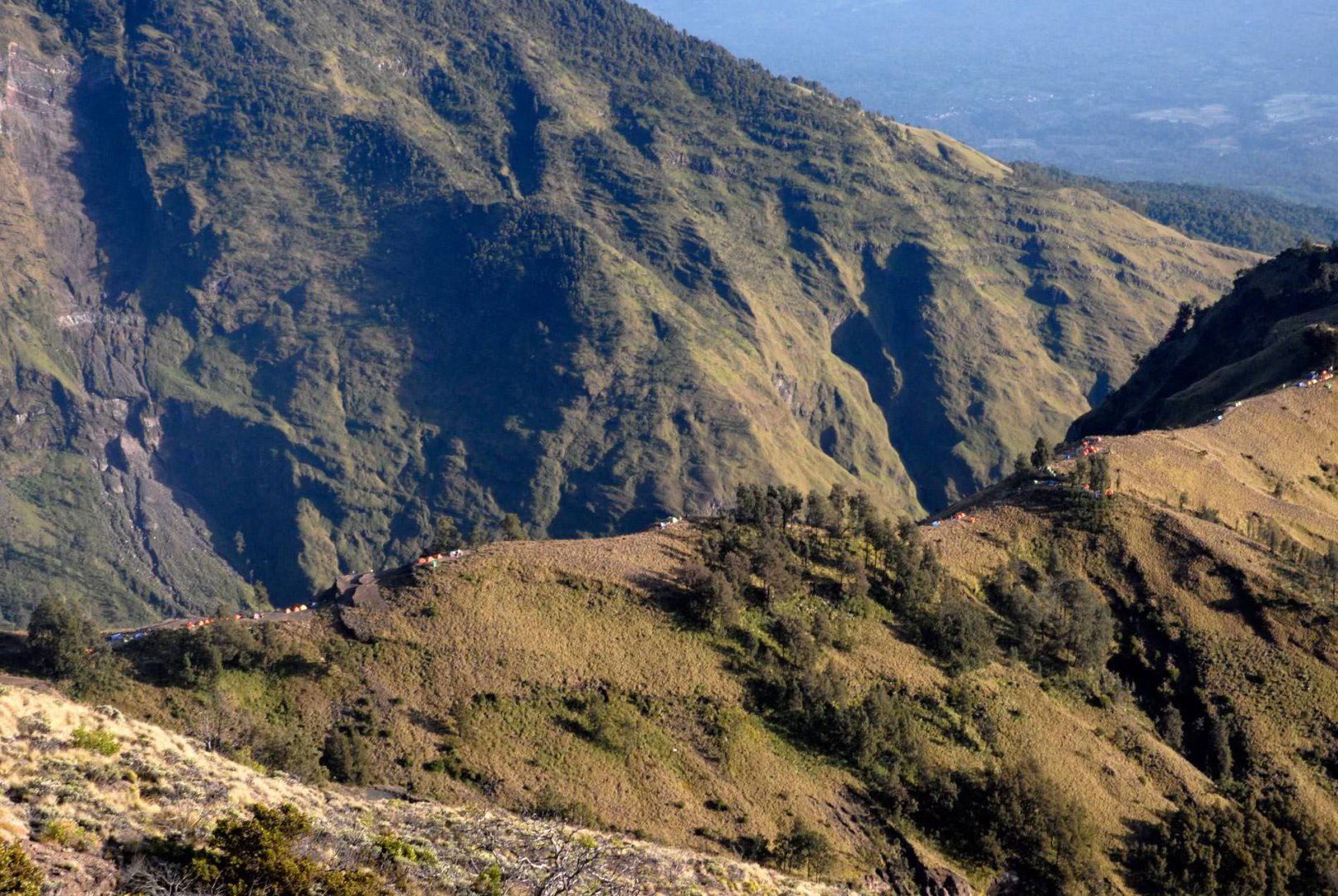
From Lake Anak 2,020m, we then continue eastwards up a rocky path, steeper towards the end, to the campsite at 2,600m. A short distance from the campsite is a turn-off to the road to Sembalun, which we will return to the next day. Again, there is plenty of room for many tents at this point. We also came across one tent of a local businessman where you could buy beer, cola and other small snacks (photo).
3. day
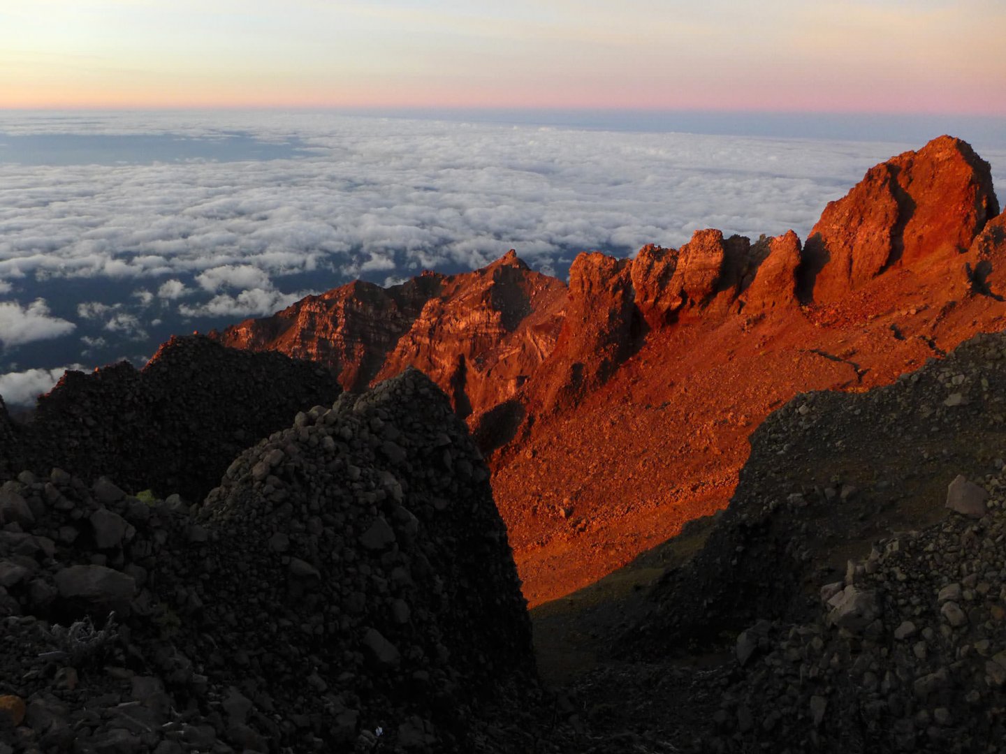
On the peak day we got up at 3am in the dark and after a small breakfast we set off. After about 200 vertical metres at 2,900m we reached the ridge leading up to the summit. From this point the most difficult passage begins, a very loose volcanic base (photo), which also makes a heavy dusting. In the upper passages from about 3,200 m above sea level, one step up and you go down half a step in the rubble. We walked without hiking poles, which would have made walking much easier.
The journey to the top takes about 3.5 hours and at the beginning it is good to have a headlamp with you. We reached the summit shortly after dawn. From the top there are beautiful views all over the island of Lombok. Also visible was the Gunung Agung volcano on the neighbouring island of Bali. From the summit we descended back to the campsite and then in a northeasterly direction to the village of Sembalun Lawang - here a car was waiting to take us back to Senaru where we had left our belongings two days earlier.
Difficulty
Due to the high altitude of 3 726 m above sea level and especially the loose and very dusty ground on the last 600 meters of altitude, I rate the hike as difficult. There is no problem with trail marking, food or drink provided by the guide and porters.
However, the high altitude is not comparable to, for example, the same altitude in the Alps. The island of Lombok is very close to the equator, where the atmosphere is denser than in the Alps. Thus, it is easier to breathe near the equator at higher altitudes than in the northern or southern hemisphere. The most challenging part was the last 600 metres or so of altitude, when on the loose volcanic surface you take one step up a steep slope and half a step backwards - you will find it much more efficient with hiking poles.
Water availability
Water was provided by our guides for all three days, who also carried provisions. They say that you can go on the trek without a guide, but it is forbidden, so we didn't risk it (no reason - guiding on Gunung Rinjani is an important source of income for locals in Lombok, and when you see how modest these people are and what conditions they live in, you will gladly give them some extra tips after the trek).
Our guides gave us about 2-3 liters of water per head for each day of the three-day trek. We saw the guides getting drinking water at the Aik Kalak hot springs (where most people on the trek refreshed themselves), otherwise we didn't see a drinking spring on the way from Senar to the summit. The exception is a small shop (or rather tent) in the campsite about 1,100m below the summit where we came across a businessman selling beer, limo, cookies, chocolates - we were very happy to take advantage of this.
Sleeping options
Thanks to our paid porters, we slept in a tent every night. Tent sites are fixed. These are the places where all groups heading to the top of Gunung Rinjani camp and you will never be alone in the summer sea
Mountain peaks
Since it is not a mountain but a volcano, you will climb only one peak on the whole trek - Gunung Rinjani 3 726 m above sea level.
During the trek, in good weather, you will see from the top of Gunung Rinjani the volcano Gunung Agung 3 031 m above sea level, which is located on the neighboring island of Bali.
Danger
The only ridiculous danger on the whole trek were the monkeys (especially on Sembalun crater rim - the second sleeping station), which could take advantage of the smallest moment of inattention and steal anything to eat. There are no exposed spots or artificial belays on the trek. Walking confidently on rocky and loose terrain, sometimes significantly steep, is a must.
Food
Food, as well as water, was sorted out thanks to the guides. They cooked us breakfasts (mostly pancakes with banana or toast) and hot dinners (usually a piece of meat with rice). We had our own chocolates and energy bars, bought earlier. Nothing more was needed.
Attractions
The price of a three-day trek including porters and guide (with food, drink, tents and transport from Mataram to the starting point of Senaru and then from the final point of Sembalun back to Senaru) cost us in 2013 about 2 500 CZK per person (the price included the entrance fee to Gunung Rinjani National Park).
Equipment for the trek to Jebel Toubkal
I recommend standard equipment for trekking - sturdy ankle boots, functional clothing, waterproof jacket, headlamp (for the peak day when you go out in the dark), sleeping bag (not included in the provided services) and especially trekking poles, which you will appreciate very much on the peak day on the extremely loose and dusty volcanic surface. I consider a trekking app on both my mobile and smart watch (I use an Apple Watch) as standard, ideally with the option of interchangeable straps for the Apple watch.
Lombok earthquake
In the caldera (crater) of Gunung Rinjani itself is another small volcano with its caldera - a kind of caldera within a caldera. Few people know that the eruption of Gunung Rinjani in 1492 kicked up so much dust into the atmosphere that the global climate changed by +0.5°C. The eruption of the volcano also created the touristy Gili Islands - Trawangan, Meno and Air, which are beautifully visible from the top of the volcano in good weather and located just a few klilometres west of Lombok.
Photos