Mountain range, region / State
Wetterstein / Germany
Season
Fall
28. 09. - 30. 09. 2023
Difficulty
C
Elevation
↑ 4009 m
↓ 4009 m
Length
33.4 km
3 days
Altitude
max. 2917 m n.m.
min. 750 m n.m.

Combined crossing of the Zugspitze - ferrata, glacier
Starting point
We left the car in the parking lot at the lower cable car station, 5E/day (IX/23) near the village of Hammerschach (Alpspitzbahn parking lot). Near the famous town of Ga-Pa.
Description of the hike
1. day
In the late afternoon we reach the cable car, where after all cheaper parking - 5 E/day, we repack, 1.5km along the track to Hammersbach and then on the marked forest path, then serpentine we enter the gorge, where we will still be grazed in the evening. The trail is great, bridges, waterfalls, alternative tunnels, but also very wet. After the gorge we climb some more, and spend the night at Höllentalanger Hütte, where we are in 2 hours.
2. day
At 6:30 we head out of the hut, still wearing headlamps for a while, through the trees, along the limestone trail to the ferrata, which is about 1/2 hour later. There are two more attractive spots - Leiter (ladder), in the form of thick cairns on smoother rock, then Brett (plank) - a traverse on pegs. Then back along the trail towards the glacier, followed by less clear rubble where the signage is a bit of a problem to navigate, but in good visibility just head towards the glacier more to the right and traverse. The glacier is thawing, bare ice smeared with rocks. We put on crampons and climb up serpentines to the next belayed section. The ascent is from a thawed crack.
First leg slightly overhanging, but nothing complicated. At first perpendicular upwards, then a rising traverse towards the top. The last section is again a bit of icy snow. The trip to the top took those 5-6 hours At the top, climbers mingle with tourists from the cable car. At least there is a snack on the Babylon platform. Descent by a secured, but easier route, so no longer necessary belay (but who wants), towards the ski area, after the ferrata again rubble and then a fairly easy descent to Knorhütte, where another overnight stay. The descent from the summit takes less than 2 hours
3. day
In the morning the weather was a bit worse, foggy, so we finally choose a longer, but clearer route to climb Alpspitze. First, through the Reintal valley past the Reintalanger Hut , which is just waking up, then onwards along a fairly easy, only slightly descending trail to the turn-off at Bockhütte (not on the map). It separates the more striking part and then brutally up again through the forest serpentines. After about 500m of elevation gain we come out of the forest, rest under Bernadeinkopf and then over rocky ground and then along the Alpspitz Ostgrat ridge and a shorter secured section to the top of Alpspitze 2 628 m above sea level, where we are at 13:30, or in 7 hours with almost an hour stop at Reintalanger Hütte. The clouds part, with tame to slightly grumpy cavies ubiquitous around. Descent down a picturesque, rather airy but iron-intensive ferrata with views of the Zugspitze, it seems that it doesn't take an end but in about 2 hours we are at the cable car, then down by cable car where the rest of the expedition is waiting and at 16:30 departure
Difficulty
The beautiful varied route is one of the more challenging but not extremely so. In 3 days we covered a decent elevation gain, in different terrains- forest, wet gorge, rocks, scree, glacier, ferrata. From Hammersbach you go along the forest path, reach the gorge, where you have to pay the entrance fee, go through a turnstile, then through a wetter path, tunnels, after which you climb to the hut.
From the hut, the rocky path continues through the valley, at first still a bit of forest, then just alpine greenery. After about 1/2 hour it's time for ferrata harnesses, but these are rather shorter, easier sections, although the "ladder" looks impressive, then another traverse on loaded pegs. The next trail is followed by less clear rubble to the glacier, where crampons have to be put on for a change. The cracks are safely passed.
The ascent from the glacier to the continuation of the ferrata is slightly overhanging, then an almost perpendicular but well belayed wall, then the summit with the cable car in sight, but the diagonally traversing route seems endless. Below the summit a snowy, more slippery passage, but all is well belayed. Crampons and poles on the glacier, no ice axe was needed, nor was any additional belaying.
Water availability
The usual 1.5 litres of water. After the first ferrata section there are places where you can refill before the glacier, then there is a restaurant at the top.
Sleeping options
On our route we slept at the huts Höllentalangerhütte and Knorhütte (possibility at other huts - the top of Zugspitze and Reintalanger).
Mountain peaks
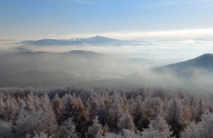
On the route we climbed the peaks Zugspitze 2 962 m above sea level and Alpspitze 2 628 m above sea level. The views are of the entire Jubilaeumsgrät, as far as the Dolomites, Piz Bernina in the distance, etc.
Danger
The dangerous places are all well secured, but this is a more demanding, exposed hike, designed for experienced travelers. It is necessary to have equipment for both the sheltered paths and for moving on the glacier. Secured routes are up to difficulty C.
Food
Food is available at the huts on the route e.g. goulash or specle. Take your regular snacks, bars, etc.


