Mountain range, region / State
/ Chile
Season
Winter
31. 01. - 06. 02. 2020
Difficulty
2 / 5
Elevation
↑ 3534 m
↓ 3635 m
Length
76.8 km
7 days
Altitude
max. 878 m n.m.
min. 37 m n.m.
Tips for hikes in the mountain range
Trek from Lake O'Higgins in Chile to Lake Desierto in Argentina
A short and easy trip to the Araucaria in the heart of the Chilean Andes
Trek to the lake in Conguillío National Park in the Andes
Several days of hiking in the most beautiful Patagonian park Torres del Paine
Starting point
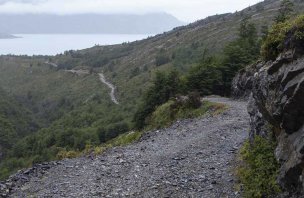
Our journey starts at the entrance to the park called Laguna Amarga, where we were brought by bus from Rodoviario Puerto Natales Bus Station. At the station, you will buy a ticket from one of the transportation companies. If you are coming from Argentina like us, you can try to save time, the bus also stops at the Paso Río Don Guillermo border crossing. After paying the entrance fee of 21,000 CLP (you can also pay in USD, don't rely on the card) we get a detailed map of the park and a short lecture about what to do and not to do, especially with fire :-) (Czechs know the area well, after a 5-day fire started by a Czech tourist the fire destroyed almost 5,000 hectares of the 181,000 hectares of the protected area and the damage was estimated at more than 100 million dollars.) Perhaps the only thing no one had prepared us for was an encounter with a cougar. After the training, we boarded a bus (5,000 CLP ticket) that took us to the parking lot at Base de las Torres del Paine (Camp central). The path from the entrance to the first camp can also be walked.
Description of the hike
1. day
Our journey starts at the entrance to the park called Laguna Amarga, where we were brought by Maria Jose's bus from Rodoviario Puerto Natales Bus Station (7 500 CLP). After paying the entrance fee (21 000 CLP can be paid in USD, don't rely on the card) we get a detailed map of the park and a short lecture about what to do and not to do, especially with fire :-) (they didn't know we are from Czech Republic, they tell everyone). After the training we boarded a bus (ticket 5 000 CLP) which took us to the parking lot of Base de las Torres del Paine - Camp Central. Where we have a tent and dinner arranged in advance.
2. day
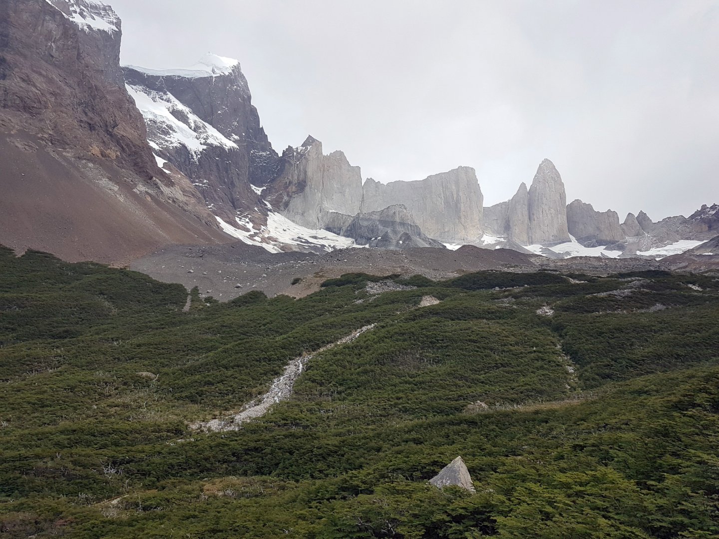
Mirador Las Torres, time approx. 7-8 h, elevation approx. 950 m, starting and finishing point the same, so the climb to the towers can be done easily. Two of us stayed overnight at the Chileno campsite, they leave their backpacks there. We start from the campsite in the morning after the rain on a well-maintained road past Hostería Las Torres. The road climbs steeply to a place called Windy pass, then the climb eases and we arrive at the Chileno refugio. From here we continue along an undulating forest and rocky path around the river, which we eventually cross on a small bridge. After the bridge we have another climb, which eventually turns into a steep ascent over a large boulder field to the Mirrador de Las Torres lookout. The descent back to the campsite is by the same route. The road from the Chileno campsite up to the towers closes at 15:00, after which it is guarded by a ranger who will not let anyone up.
3. day
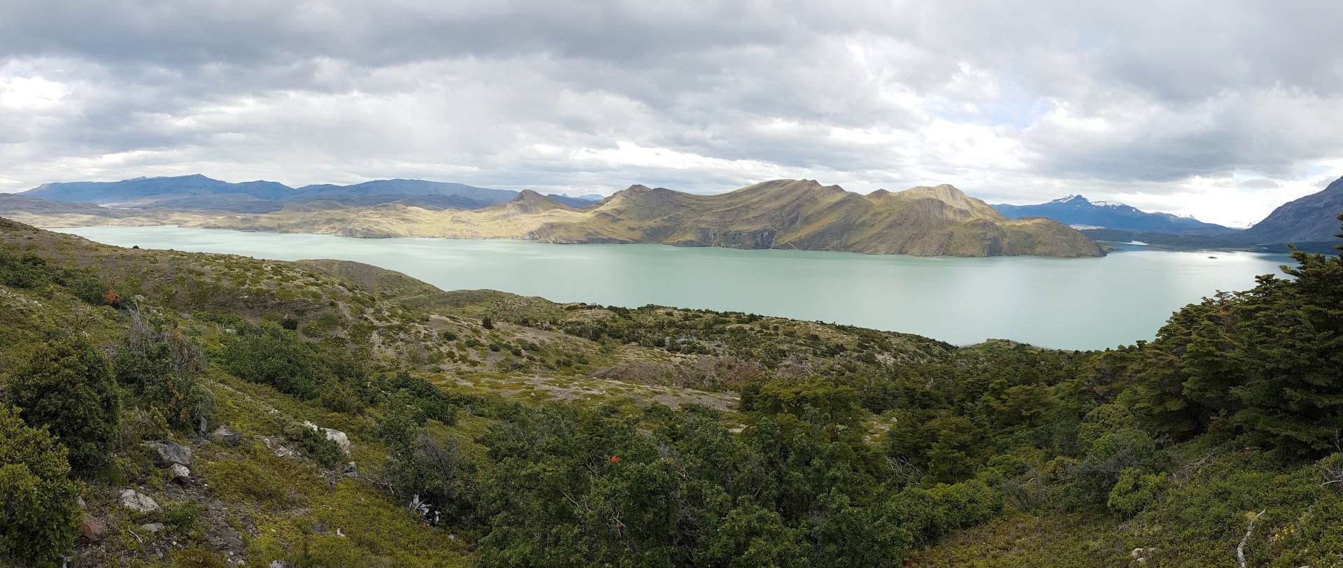
Los Cuernos, time approx. 5 h, elevation approx. 460 m. This part of the trail runs along the mountain ridge below the formation called the horns - Los Cuernos on the right and the long lake Nordenskjold on the left. From the Central campsite we take a slightly undulating open terrain around the lake. The route is easy and rather relaxing after yesterday's climb.
4. day
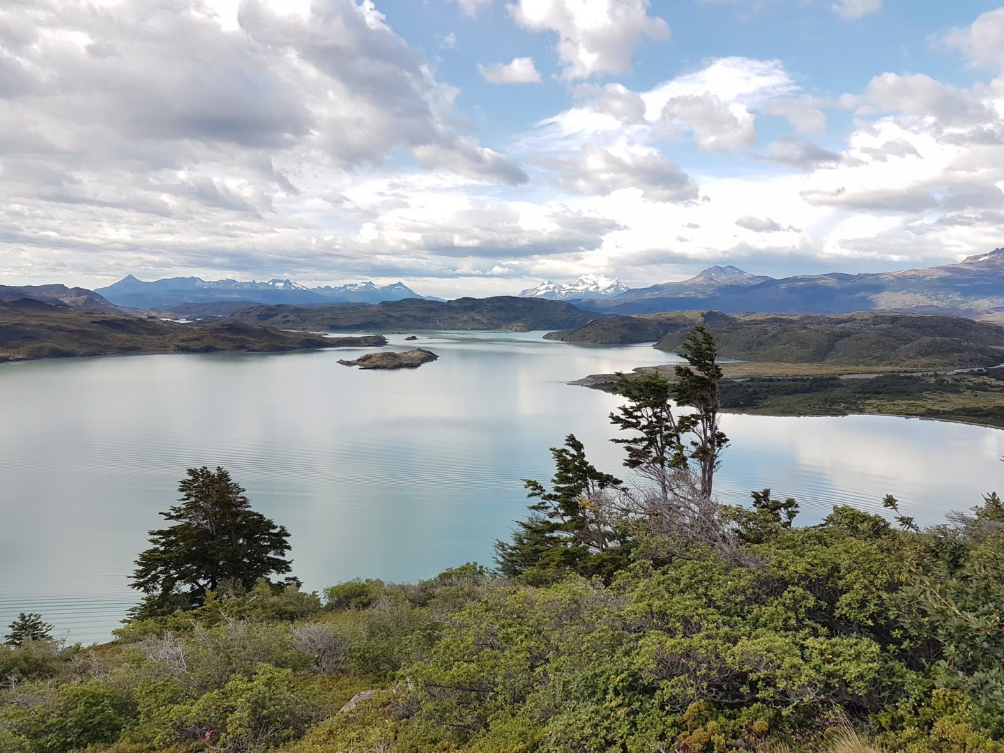
Vallee des Frances, time approx. 9 h, elevation approx. 723 m above sea level. From the campsite below Los Cuernos we follow the rhizo-bush overgrown, slightly undulating path to the Frances campsite, where the trail starts to climb and after some time it will lead us to another campsite nestled among the trees - Campo Italiano (not working at that time). Here we leave our packs and continue walking lightly, as we will be returning this way again. The path climbs through the forest, then passes between bushes and the forest again. After about an hour we reach a rocky lookout in the middle of the wild and rocky peaks of the French valley.
All along the way, we can enjoy the views of the Frances Glacier and its cracking and falling avalanches accompany us to the next viewpoint, Mirador Británico, where the route ends. The route back to Campo Italiano is the same. Here we again load our backpacks and continue across the suspension bridge towards the Pehoe Hosteria (Refugio Paine Grande) on the shores of Lake Pehoe. The path leads again through a gently undulating landscape full of slash and burn, then through a field of scorched earth, where one realises why fire is forbidden everywhere. The avenues of white, charred trees around Skottsberg Lake can be a little depressing. A slight climb follows and just over the hill Refugio Paine Grande peeks out.
5. day
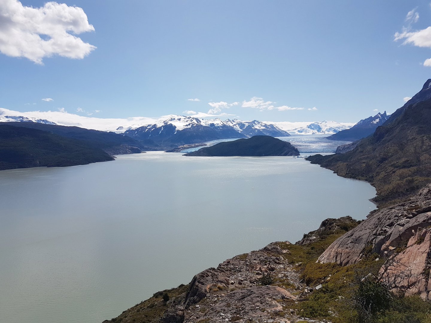
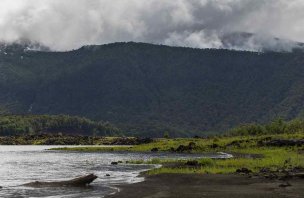
Glacier and Grey Lake, time approx. 4 h, elevation approx. 458 m above sea level. From Lake Pehoe we head north into the rocky gorge. The trail first passes through a mountain valley before views of Grey Lake open up, with blue ice floes floating on its grey surface. The trail around the lake is easy and I recommend making your way through the campground to the glacier overlook. Or to the beach, where the more adventurous among you can take a dip. There is also a base near the beach for hiking on the glacier (all equipment is available for rent, price approx. 2 500 CZK), or kayaking under the glacier, or you can arrange to climb.
All the water in this campsite is grey, straight from the lake. Don't worry, the water isn't dirty, it's full of sediment from the movement of plates under and near the glacier. The parts of the glacier you will see above the surface are about 10% of its entire size, and the whole 60 million year old beauty is just one "finger" of the huge hand of the Patagonian Icefield.
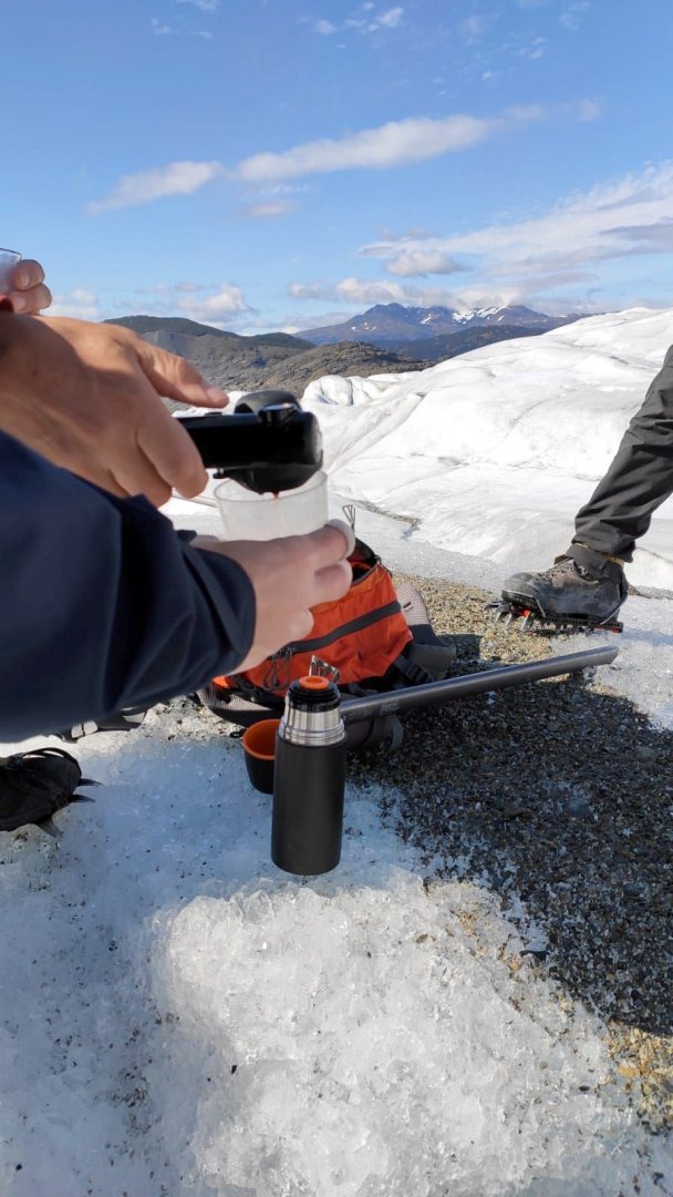
6. day
Grey Glacier and Paine Grande, time 3 + 4 h, elevation approx. 458 m above sea level.In the morning after breakfast we take a boat to the glacier and move to the starting point by stones and ladders. After a thorough briefing we have a beautiful approx. 2 hours of walking on the glacier, exploring the crevasses, the Patagonian Dragon and views of the surrounding mountains. The path on the glacier is not marked on the map. After the glacier trek we pack up and head back to Paine Grande. One of the interesting facts from local climbers is that the mountain seen from the glacier is called Ostrava, after the place where its first climber lived (it's a heavy mountain). So in the end we left this place knowing that we as a nation are not known only for arsonists :)
The Patagonian Dragon is a very primitive insect that spends its entire life in the glaciers of the Andean southern ice field. The only member of the wingless family, it has a high concentration of glycerol. It feeds exclusively on algae particles growing in tiny crevices in the ice. As this part of the world is inaccessible and uninhabited, encounters with these insects are very rare and I am glad we were able to do so.
7. day
After breakfast, we take the first catamaran across the lake (30 min) to Guarderia Pudeto - the bus stop, from where we head on to Argentina, where a new adventure awaits us and especially Los Glaciares National Park.
Difficulty
The trek leads through mountain terrain on "groomed (marked) paths", rocks, sand, dirt, rope bridges and in some places through a stream. There are no technically challenging sections along the way. Ankle boots are not strictly necessary for the trek, it can be done in low shoes, some parts even in canvas or sandals. For untrained individuals, perhaps the only limit is time, as you ideally have to reach the campsite before dark (max 13 km section). Some parts of the trail can be uncomfortable in the rain, when the proverbial Patagonian winds (about 60 km/h for us) lean against you. I only saw kids in the park on the first day when we hiked up to Mirador Las Torres (locals have it as a day trip and it's the most secluded part of the park), strollers in general and pets are not allowed in the park.
Water availability
Water can be replenished at each campsite, and from streams and lagoons/lakes along the way. No filter tablets, UV lamps and other gadgets are needed (tested on humans).
Sleeping options
Overnight options in the Tores del Paine Park are as follows: own tent, rented tent, refugio (bed under the roof). We have tried renting a tent, just a sleeping bag and a mattress of our own, but it is possible to rent that as well. Everything was without problems.
Mountain peaks
There are no marked peaks on the route.
Danger
Probably the biggest danger was when we met an adult cougar in the morning after breakfast in a convivial conversation in the kemu central. You don't quite know what to do, you only know stories about the encounter - prevention against bears, dogs, etc. But a cougar? omg. Cat colossus 3 meters in front of us, looking at us :-) Nobody even bothered to take out the camera, luckily everything turned out well and it makes a nice story. On the way, in some places watch out for slippery rocks when crossing rivers or in the rain. Also rope bridges and fast changing weather, forecasts don't work well here and the locals will only tell you one thing: "Don't ask us for the weather, leave Patagonia." :)
Food
In Toress del Paine there are several options, food provided on site or self-catering, including your own cookers etc. Each campsite has a cooking area but it is without equipment (ingredients, utensils, cooker). I only saw ingredients available for purchase at Camp Grey and at the campsite at Lago Pehoé (pasta, rice, canned food). We have tested the food in the campsites and there is nothing to complain about.
Attractions
The following information may help other people who decide to visit this beautiful part of our planet on their own. We didn't have much information about the food in the camps before we left, all we wanted was not to suffer from hunger and not to have to carry canned food, cooker, dishes on our backs. If I knew what I know today, I'm sure just breakfast and dinner would have been enough, during the day a candy bar would have been enough :) Breakfast (12,000 CLP) - toast, eggs, ham, cheese + drinks. Lunch (14 500 CLP) in the form of a Lunch box - baguette, bars, fruit, nuts, chocolate. Dinner (22 000 CLP) - soup, main dish, dessert + drinks. They also have a veggie option on the menu. We booked the food, as well as the tent site, tent rental, bed, etc. in advance here and here Arrival and departure to the park, including the catamaran, was handled through Maria Jose. Czech operators have no signal in the whole park and WIFI is charged 5 min 1 USD, 1 h 5 USD, 3 h 8 USD.
Photos