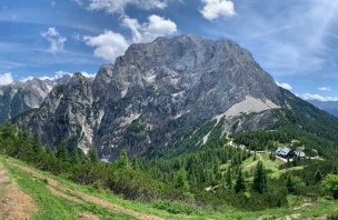
Mountain range, region / State
Julské Alpy / Slovenia
Season
Summer
05. 07. 2023
Difficulty
1 / 5
Elevation
↑ 125 m
↓ 124 m
Length
3.4 km
2 hours
Altitude
max. 626 m n.m.
min. 569 m n.m.
Tips for hikes in the mountain range Julské Alpy
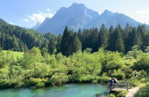
Trek to the Zelenci National Reserve in the Julian Alps
A trip to Mount Vršič from a mountain saddle in the Julian Alps
Trip to the Savica waterfall at Lake Bohinj
Family trip to the Mostnica river canyon in the Julian Alps
Starting point
Paid parking behind the village of Stara Fužina. Parking costs 3 Euro per hour.
Description of the hike
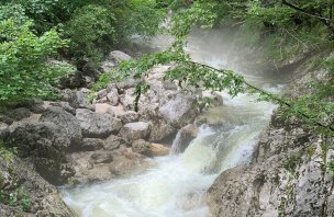
At the parking lot we were greeted by a barrier and a classic around Bohinj Lake - 3 Euros for an hour of parking. Ugh. From the parking lot we headed down the wide road towards the Mostnica River. Along the way, we came to the Devil's Bridge and then to a booth that charges admission to the Mostnica River Canyon. 4 Euros adult, 2 Euros child 6 and up. We then crossed the bridge to the other side of the river and followed the trail along the riverbed. Right at the beginning, the river cuts into the rock, creating a fissure several meters deep through which it flows. We continued upstream. Soon we came to another rocky passage, where the most famous rock formation on the river is - the elephant's head. We continued along the river and climbed gently.
Unfortunately, the weather forecast started to be quite bad and instead of the sun, heavy clouds were rolling in from the mountains. Therefore, after crossing the river on the bridge we decided not to continue to the hut about 800 meters away. Moreover, we were discouraged by the crowds of people heading there. In the end it was a good decision. On the way back along the other bank we could continue to enjoy the beauty of the Mostnica riverbed. After a short rest we started to return faster as it started to rain lightly. Unfortunately, the rain turned into a proper thunderstorm and we quickly walked back to the car park. At least we saved some euros for parking longer...
Difficulty
A simple hike around a mountain stream. The elevation is minimal, the whole time you walk along a forest trail. The trail can be extended further into the mountains, we had to cut it short due to a storm.
Water availability
On our route there was no possibility to refill water. Less than a kilometer further into the valley there is a hut where you can refresh yourself. We had about 0.5 liters per person of water.
Sleeping options
Accommodation is available in the villages around Lake Bohinj. There is a large offer of apartments or campsites.
Mountain peaks
The route goes around the Mostnica River, so it does not go over any peaks. There are limited views of the Julian Alps.
Danger
It is definitely necessary to be careful on the edge of the cracks created by the Mostnica River. In places it is over 10 metres deep. Railings have been installed in some places, but not everywhere.
Food
There was no hut on our route. Planinski Dom is located about 800 meters deeper into the mountains. We didn't get there because of the storm.
Photos