Mountain range, region / State
Dolomites in Alps / Italy
Season
Summer
23. 07. - 28. 07. 2023
Difficulty
3 / 5
Elevation
↑ 6947 m
↓ 7983 m
Length
104.5 km
6 days
Altitude
max. 2573 m n.m.
min. 458 m n.m.
Elevation profile of the route
Useful information
- Day 1 - start at Lago di Braies, end at Lé de Limo, 20km, 1600m ascent, 1000m descent
- Day 2 - start at Lé de Limo, end at Cason de Formin, 24km, 1500m ascent, 1800m descent
- Day 3 - start at Cason de Formin, end at Lago di Coldai, 20km, 1200m ascent, 900m descent
- Day 4 - start at Lago di Coldai, end at Casera del Camp, 16km, 900m ascent, 1200m descent
- Day 5 - start at Casera del Camp, end near Casera la Varetta, 25km, 1800m ascent, 1900m descent
- Day 6 - start near Casera la Varetta, end on the road to Belluna, 13km, 100m climb, 1300m descent
Tips for hikes in the mountain range Dolomites in Alps
Circular trek at the waterfalls in the Fanes Sennes Braies park in the Dolomites

Trek with the best ferrata in the Sexten Dolomites

Circuit trek with ferrata around Monte Paterno
Alta Via 1 - long-distance route in the Dolomites
Starting point
The trek starts from Lago di Braies. There is a paid parking lot at the lake, but we used the local bus and drove to the lake from nearby Niederdorf-Villabassa.
Description of the hike
1. day
The trek itself started at Lago di Braies, where we arrived the evening before and where we also spent the night. The trail from the lake begins to climb immediately and tests your fitness right at the start with 900 vertical metres to the first saddle, where the reward is a beautiful view of the mountains and meadows. There is a hut just below the saddle where you can refresh yourself and a few hundred metres further down the road you can also refill your water. The path from the hut continues for a few km almost on flat ground and after a slight descent we slowly reach another hut, where there are quite a few people, because there are also cycle paths leading here.
We refill water and taste local food in the restaurant. From this hut there is a wide paved road, which eventually turns into a small "road" that descends steeply into the next valley (my knees didn't exactly dance twice on the descent). In the valley there is another possibility to refill water or to have something to eat in the next hut. We cool our hones in the icy water of the stream for a while and head uphill again. Here the climb is rather milder but persistent. After a few kilometers we pass 2 huts with food and only in the 3rd hut in the sequence we stop for a snack. Then we have only a few meters of altitude left to the lake, where we unpack our sleeping bags and cook dinner.
2. day
In the morning we pack our things and head out to meet the next day. After a while we get to the first hut, which is still closed in the morning, but has water brought out, so we replenish our supplies. The journey continues through beautiful valleys with views of the surrounding peaks. After a couple of kilometres we turn off onto a smaller gravel path and start to climb up one of the saddles. From the saddle we have a beautiful view of the valley we came from and a little below the saddle we also get a view of the continuation of our journey. From the saddle, we have a steep descent to a small lake and from there we climb gently again to the next saddle. After a few kilometres and another descent we reach the road from Cortina d'Ampezzo.
There is a small souvenir shop, but they also have a few pastries and baguettes. From the road, the road climbs up the slopes, goes around the top of Averau and reaches the Cinque Torri. In the surroundings you can see the remains of the wartime trenches. From Cinque Torri we descend to another road. The road is quite pleasant through the forest, but in the rain it becomes one big muddy slide. From the road we were only a short distance from a small hut, which is unfortunately locked, but there is a wide enough space in front of the entrance to stretch a tarp over and sleep 2 people in the dry.
3. day
In a moment without rain we pack our sleeping bags and head towards Lago Federa. Here we refill water at the hut and continue to the nearby pass. Part of the road beyond the pass is again on dirt, so quite slippery in the rain. Gradually we descend lower, the path goes more along meadows until we reach a wider paved road that leads us to another hut. Here we have a snack and then continue through the forest to the road. Here, unfortunately, the path goes along the road, but most of it can be managed behind stiles, so at least one does not have to dodge with cars.
At the point where the sign again deviates from the road, we refill the water and continue along the wider paved road again. After a couple of kilometres the sign also turns off this paved road and continues on just a small footpath through a meadow. Once again we enter the downhill area until we reach the bottom of another prominent hill. There is an opportunity to refill water before the climb. A fairly intense climb follows, which brings us to the hut and just beyond it we reach a saddle, from which there is already a view of the lake at which we will spend tonight.
4. day
On the 4th day we had a rather relaxing portion of kilometres. At the beginning the road goes under the massive peaks of the surrounding mountains. After some time it starts to gradually descend until it reaches the lower pastures. After a few more small climbs and descents we reach the hut where we refill water and something good for our stomachs. From the hut we descend on a larger paved path and need to be careful where to turn off again onto a smaller footpath. From the turnoff we start climbing again. First through the forest, as time goes on the forest diminishes, views begin to open up and the taller trees are increasingly replaced by brush. At the end we descend a few vertical metres off the trail to a beautiful hut, which is freely accessible and we spend the night here.
5. day
We leave early in the morning. After climbing back to the marked path we continue on a short descent almost along the contour to the next hut. But here there are a lot of people going to ferrata and climbing, so we don't stop and continue on. After a few kilometres we pass 2 buildings in a small meadow and refill water. The road slowly starts to descend until we reach the road. The trail continues to descend for a few kilometers down the road. Here you need to be careful where to disconnect from the road, as Alta Via 1 is wrongly marked at the signpost and would drive you further down the road. But we turn off onto a forest path and start climbing through the forest. The forest is occasionally replaced by rubble fields until finally the forest turns into a cage and we pass two typical alpine buildings to reach the saddle. At the houses there is still a possibility to refill water.
After the saddle, the path descends slightly and then follows the contour line for some time. After about 2km we reach a fork where we make a small detour to a hut for refreshments before the last major climb of the trek. From the hut we then return back to the fork and continue on the marked trail. First we climb up a narrow path, which then turns into a path directly on the rock and then again into a gravel path. From the saddle we have a steep descent through the meadows to the hut, but we only pass it and continue the last few kilometres to the place where we will sleep.
6. day
On the last day we only have to descend to the road, from which we leave by bus to Belluno and then take the train home.
Difficulty
The difficulty of the trek lies mainly in the steep descents, where the knees of every hiker are tested. The trail is mostly a narrow gravel path, in some places going directly on the rock, but no exposed sections. The actual descent back to civilization is on a wide paved path towards the end. The whole route can be managed without belay elements. Some slopes are steep, but the path is easily passable. The highest point of the trail is at just under 2600 m above sea level, so altitude sickness is very unlikely. For me, the hardest part of the whole trek is the very first day, when one's legs have not yet parted and directly from the lake one is faced with almost 900 vertical meters for less than 5km. We didn't have our dog with us, but none of the sections should be a problem for the dog. However, the trail is definitely not suitable for children in a stroller and I would rather not recommend it for small children either. We carried sleeping gear, a waterproof jacket, trekking boots and walking poles.
Water availability
There is no problem with water on the trek. It can be replenished at the huts or filtered from the lakes along the way.
Sleeping options
We carried all our sleeping gear with us. There is also the possibility of sleeping in huts on the way.
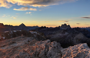
Mountain peaks
The surrounding landscape is very variable. There are views of countless peaks along the way. It is possible to turn off the main trekking route to some of them, or to complete the trip with ferratas in the surroundings.
Danger
The journey is quite comfortable. Only some sections are quite slippery in the rain, but I didn't feel uncomfortable on them anyway.
Food
We carried our own food for the whole time. There are a considerable number of huts along the way where you can eat, or just use them for a small snack. I recommend trying the fruit pies and savoury plates they have at some of the huts.
Attractions
The trek passes through 2 national parks. In some places you can see the remains of the first world war, around some of them there is a direct road (Cinque Torri) to others you have to turn off using ferrata equipment.


