Mountain range, region / State
Ybbstal Alps / Austria
Season
Summer
10. 07. 2023
Difficulty
1 / 5
Elevation
↑ 430 m
↓ 433 m
Length
6.0 km
3 hours
Altitude
max. 1808 m n.m.
min. 1482 m n.m.
Tourist map of Hochkar
Tips for hikes in the mountain range Ybbstal Alps

Spring crossing of the three Zellerhüte in the Ybbstal Alps

Climbing the Gippel peak in the Ybbstal Alps
Sightseeing route around Annaberg in the Ybbstalian Alps
Summer family trip to Hochkar from the car park at the lifts
Starting point
We deliberately go to Hochkar on Monday, when the cable car and most of the tourist facilities are closed, and we choose to hike to the top on a marked route with a pleasant elevation gain of about 300 metres.
We take the panoramic road out of the valley from the village of Lassing to the car park by the lifts, where our trek begins. There is a toll gate at the beginning of the road, but due to ongoing road maintenance or a day off, no one wants to charge us a toll.
Description of the hike
There are only a few cars in the parking lot, mostly company cars, and on Mondays the cable car is being maintained and the huts are being restocked. We pass between closed hotels and shops and head up past the wooden Hochkarkapelle. Traverse across the slope where cows graze in summer and continue along the path to the Scheinecksattel (1,530m).
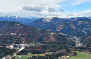
Here the trail reverses and climbs along the edge of the mountain further to the top of the Hochkar. Beyond the saddle, views to the west appear. The nearby hills are Stumpfmauer and Hochkogel, situated on the tri-border of Lower Austria, Upper Austria and Styria. Behind them is the Gesäuse and in the distance the Haller Mauern and Totes Gebirge.
Kneeling we climb up to the alpine meadows, full of flowers in July. From the Yoga Wiese (Yoga Meadow) the summit cross is already visible. A few dozen metres and we are standing on the top. The view is perfect - the nearby Gesäuse with the Grosser and Kleiner Buchstein, the pointed Lugauer, the Hochtor to the west, the Hochschwab and the Ybbstal Alps on the other side.
After resting for a while, we descend back to the meadow and continue to the top station of the cable car. From there, a tarmac path leads to the 360° Skytour attraction - a viewing platform above the south face of Mount Noten (1780 m). On a quiet day we are alone here, so we enjoy the view and recognize the mountains from the panoramic photos. Around the transmitter we then descend down the slope.
We stop at the Steirertörl viewpoint - the gateway to Styria. After a wide road and slopes, we return to the ski town. Those who wish can continue on over the Häsing, Leckerplan and Schmalzmauer peaks to the easternmost part of Hochkar. A marked trail will then take you past the artificial lake Bergsee down to the car park.
On the way back, we stop in the nearby town of Lunz am See for a swim in the eponymous Lunzer See. The cool water of the mountain lake is pleasantly refreshing. At the wooden marina we feed Austrian fish with Czech rolls and climb the last hills of the day - this time only ice cream from the local pastry shop.
Difficulty
Hochkar is one of the closest Austrian ski resorts from the Czech Republic. It lies on the border of Lower Austria and Styria. In summer, you can enjoy a nice hike and circular views from the 360° Skytour viewing platform. There are several ascents of the Hochkar (1,808 m) - with the help of the cable car you can do it even with a small child and vice versa.
Those who want a high-altitude experience can take the more challenging ferrata (C+) under the cable car, or they can go around all the hills around the cauldron - Hochkar, Noten, Häsing, Leckerplan and Schmalzmauer, then go on a full-fledged mountain hike with an elevation gain of around 1,000 m.
Water availability
This is an easy trip, for which you will need a maximum of 1 litre of water. You can refresh yourself at the beginning and at the end of the route in the ski resort, where there are more restaurants. There is no other water source on the route.
Mountain peaks
We will climb two peaks on this trip: Hochkar 1 808 m above sea level and Noten 1 780 m above sea level. The views from the ridge and the peaks will take you to the Gesäuse National Park, the Totes Gebirge, the Hochtor, the Hochschwab and the Ybbstal Alps.
Danger
The route is not dangerous, there is no danger. It is also suitable for older children, with the use of a cable car and for those who do not suffer much from hiking.


