Mountain range, region / State
Šumava / Czech Republic
Season
Winter
04. 02. 2023
Difficulty
2 / 5
Elevation
↑ 562 m
↓ 562 m
Length
17.9 km
5 hours
Altitude
max. 1312 m n.m.
min. 863 m n.m.
Tourist map of Sumava National Park
Elevation profile of the route
Useful information
- Suitable for children - YES (school age)
- Suitable for stroller - YES
- Overcrowding - medium
- 4. 2. 2023 - at noon arrival to Prášil, the route almost exactly 5 hours, before 5 pm back at the car and in the falling darkness return home.
Tips for hikes in the mountain range Šumava
Winter trip from Modrava to Březník
A short trip to the ruins of Vítkův kámen in Šumava
Winter hike to Poledník from Prášily
Winter snow wading on Prášilské jezero and Poledník in Sumava
Starting point
Die Wanderung beginnt auf dem gebührenpflichtigen Parkplatz im Dorf Prášily, der an Wochenenden in der Regel ziemlich voll ist, aber es gibt immer Platz. Abgesehen von diesem Startpunkt kann man auch über den Parkplatz Poledník Slunečná zum Ziel gelangen, aber am Wochenende ist es fast unmöglich, mit einem größeren Auto sicher zu parken.
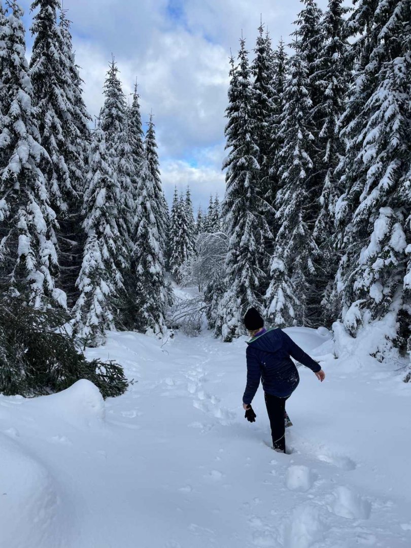
Description of the hike
We started the trek at the parking lot in the village of Prášily and continued to the official starting point, the Slunečná parking lot, which is usually so full on non-working days that we didn't even try it. Before that, we wanted to try another access route to Poledník and turned onto the red hiking trail, which is also the famous Czech Trail.
However, due to the huge amount of snow on the trail, we were unable to continue without snowshoes, so we returned to the yellow hiking trail and followed it to the Slunečná crossroads, where you need to change the yellow markings for green ones and walk to the Liščí díry signpost, from which you can go right to Prášilské jezero or left straight to Poledník.
We walked to Prášilské jezero to return to Liščí díry and then followed the red marking to the top of Poledník 1 315 m above sea level. Here we took in the views, replenished our energy through a snack and, avoiding the numerous cross-country skiers, took an absolutely identical route back.
A circuit can be made on this route (although not complete) via the aforementioned red hiking trail, which leads the hiker from Prášil by the back way to Prášil Lake and from there on to Poledník. In the presence of snow, however, it is impassable in classic hiking boots.
Difficulty
The trek is not very difficult, provided that one has already done a similarly long hike (an elevation gain of almost 600 metres on a nearly 20-kilometre hike). The trail is made of asphalt or gravel during the whole section, but in winter months its passage without snowshoes is much more difficult and at least without ankle hiking points it cannot be completed. The branch to Prášilské jezero is also in summer (spring, autumn) a forest path.
There are no steep slopes on the path, only about a kilometre before the destination there is a section with a steep elevation, on which care must be taken against oncoming cyclists, in winter against cross-country skiers. They are not visible in the curve, just as they do not see oncoming tourists. Nausea from the altitude is not felt by the proficient hiker, Poledník lies at an altitude of 1315 m above sea level, the starting point of Prášily is about 900 m above sea level.
The most difficult passage is the aforementioned slope inclined to a right-hand curve. However, no belaying is needed on the whole route. This is true even in unfavourable, wet weather. The trail is also suitable for dogs, but no personal experience. Only numerous dogs can be found on the route even in winter, so the route is not difficult for them even in the presence of snow.
As far as the stroller is concerned, it is possible to complete the route with it in the non-winter season, but it is certainly advisable to have complementary alternatives with you. I'm not a parent yet, so I haven't tested it.
Hiking equipment
In terms of equipment, warm winter clothing and proper hiking boots will serve you well even in the worst snow conditions, or for more comfort snowshoes.
Water availability
In the winter, a bottle of 1.5 litres per person was enough, but when covering the given less than 20 km in the hot summer, more water will certainly be needed. We had water brought from home.
Thirst can certainly be quenched in the refreshment at the finish, i.e. at the lookout tower on Poledník, there is also a possibility to buy supplies for the return journey. Unfortunately, I have no idea about the existence of springs on the way.
Sleeping options
We did not spend the night on the trail, but directly on Poledník there is one of the few legal accommodation places in the Šumava National Park.
Mountain peaks
The highest peak of the route was the destination itself, i.e. Poledník. There are no other reachable peaks in the area.
From Poledník itself, in good weather, one can observe the peaks of the Alps, and from the classically visible peaks one can observe on the German side of Šumava the Big (1453 m above sea level) and Small Roklan (1399 m above sea level) or Luzny (1373 m above sea level).
Danger
There are also wild animals (wolves, lynx) in Šumava National Park, but they stay away from tourist-exposed places for a long time, so there is no need to be afraid of their presence. Nor is there any dangerous terrain on the route.
Food
Since the refreshments on Poledník were closed in such freezing conditions, we ate on the way through prepared snacks from home.
Attractions
The route leads in the Šumava National Park, in the vicinity there are also several zones of the National Park where entry is prohibited. One of them consists of the whole surroundings of the Prášil Lake itself and the adjacent lake wall.
An interesting feature is the surroundings of the lower part of the route, which served as a military training ground during World War II; warning signs are placed along the route to warn of the possibility of unexploded ordnance.
Photos