Mountain range, region / State
/ Chile
Season
Fall
01. 10. 2012
Difficulty
2 / 5
Elevation
↑ 552 m
↓ 551 m
Length
17.8 km
6 hours
Altitude
max. 4248 m n.m.
min. 3851 m n.m.
Tips for hikes in the mountain range

Popular W Trek in Torres del Paine Park in Patagonia
Trek from Lake O'Higgins in Chile to Lake Desierto in Argentina
A short and easy trip to the Araucaria in the heart of the Chilean Andes
Hike to Miscanti lagoon under the volcanic complex of Miñiques
Starting point
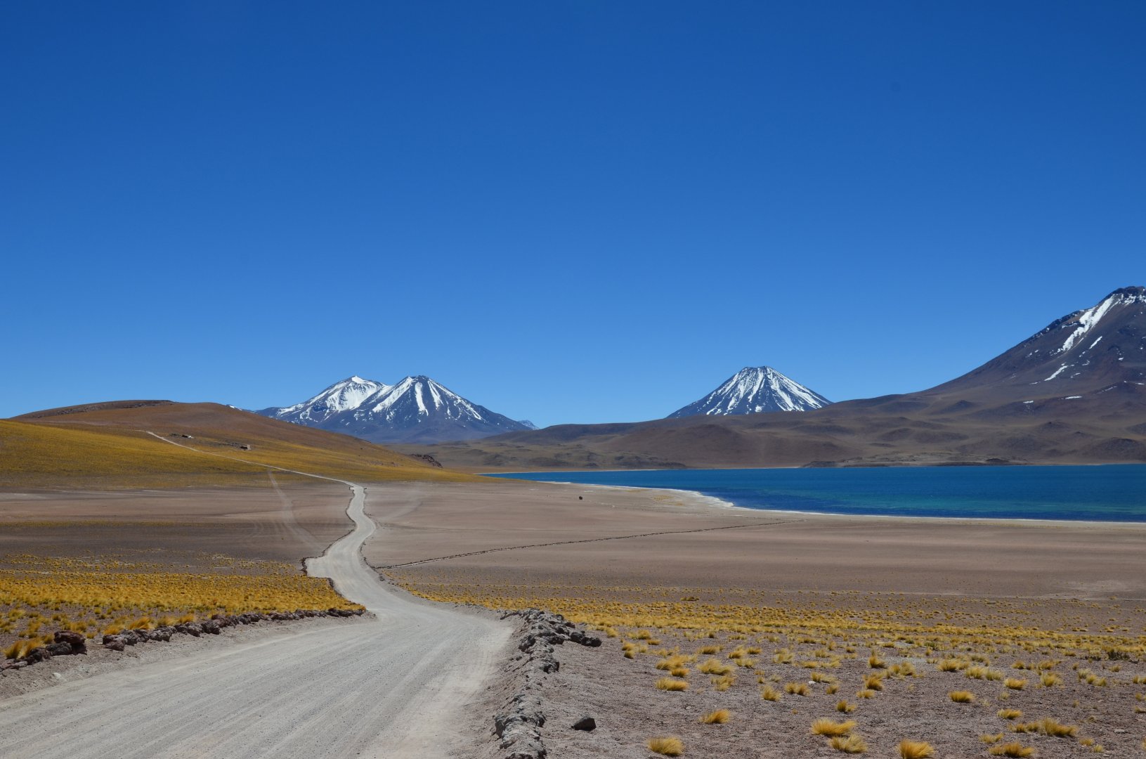
Small marked parking lot at the beginning of the road to the lagoons. Exit from the 23CH road leading from San Pedro de Atacama. Signs on the road point out the turnoff to the lagoons.
Description of the hike
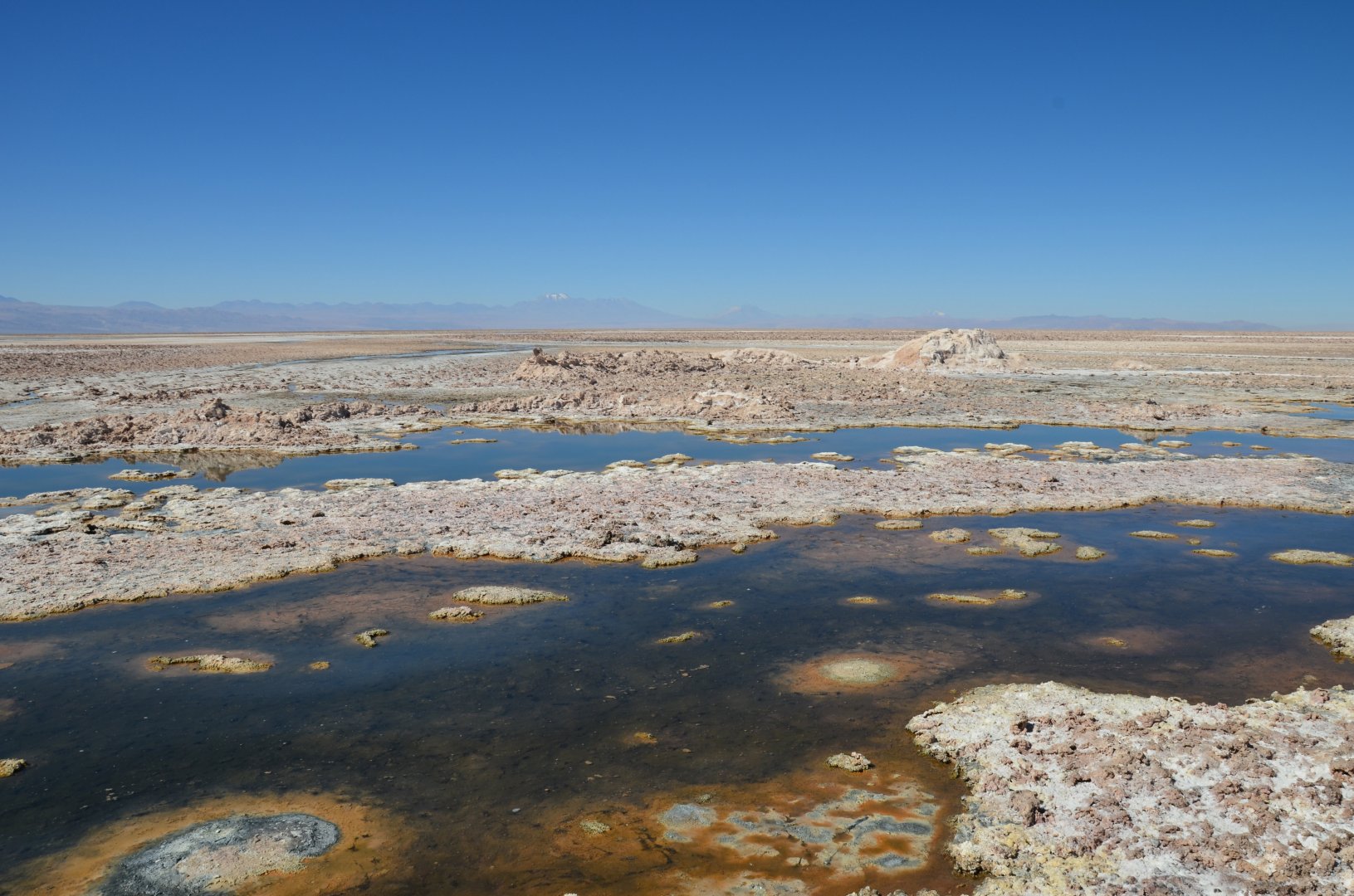
The trip to the Miscanti and Miñiques lagoons, which are located in the Altiplano plateau in northern Chile, starts at the parking lot off the CH23 road. From the parking lot, we take a wide, well-maintained road. The road is not marked in any way, but it is the only one that leads from this parking lot to the lagoons. We pass salt hills on the way and continue through the distinctive yellow rocky landscape that surrounds us. All the time we get amazing views of the surrounding volcanoes, such as Cerro Miscanti and Cerro Miñiques. The road first goes gently uphill and then descends to the lagoons. However, there is no steep climb. It will lead us safely to the Miscanti lagoon.
Here we rest for a while and enjoy the views. Then we continue on to the Miňiques lagoon, where the hiking trail ends. We return to the car by the same route. For any other visitors, I recommend a visit to the nearby Los Flamencos reserve, where you can see Chilean flamingos. This reserve is located about 4 kilometers from the parking lot to the lagoons on Route 23CH.
Difficulty
The trip leads along a perfectly groomed path and can be managed even by an untrained person or child. The elevation gain is minimal, the profile of the paths is not steep. The only problem may be the movement at a higher altitude of about 4 120 m above sea level. I recommend to acclimatize gradually before entering these heights. Approaching this height from the sea would be quite uncomfortable for most people (headaches etc.).
Water availability
All water (we had 2 litres per person) must be taken with you. There is nowhere to buy water along the way.
Sleeping options
I don't know of any in the area, we have tried Residencial Casa Corvatsch in San Pedro de Atacama - I can recommend it, good price, service is also good.
Mountain peaks
There are no peaks on this route, but there are fantastic views of the surrounding volcanoes, such as Cerro Miňiques 5,910 m above sea level and Cerro Miscanti 5,622 m above sea level.
Danger
The road to the lagoons is wide and safe. There are no exposed sections. There is nowhere to get lost, the road is well maintained. The only problem is the altitude, which can cause problems, as the lagoons are located at about 4200 m above sea level. That is why this route has a difficulty rating of 2.
Food
There is no possibility to buy food or drink on this trek, it is through uninhabited countryside. For us a candy bar and chocolate was enough to eat.
Attractions
Los Flamencos National Park was established in 1990. It consists of seven sectors with a total area of 73 986 ha. It lies at an altitude of almost 2 400 m above sea level on the northern edge of the vast salt basin known as the Salar de Atacama. Laguna Miscanti, at 4 120 m above sea level, covers an area of over 13 km² and lies in the Atacama Desert.
The Atacama, also called the Puna de Atacama, is the driest desert on Earth and is located in South America. The desert stretches for 1,000 km around the Pacific Ocean, from the southern border of the mountainous state of Peru, to the northern regions of Chile. A lava flow from the Miñiques eruption divided Lake Miñiques into 2 lakes, Miscanti and Miñiques.
Photos