Mountain range, region / State
Ennstal Alps / Austria
Season
Summer
29. 07. 2023
Difficulty
3 / 5
Elevation
↑ 1808 m
↓ 1809 m
Length
18.4 km
8 hours
Altitude
max. 2021 m n.m.
min. 641 m n.m.
Tips for hikes in the mountain range Ennstal Alps

Climb to the top of Scheiblingstein in the Ennstal Alps
Hike to the Wasserklotz lookout in Kalkalpen NP
Climb to the Eisenerzer Reichenstein from the Präbichl saddle
Climbing the Tamischbachturm in the N.P. Gesäuse
Starting point
Mühlbach - Ennstaller Hütte car park (free, spacious), from the side road between Sankt Gallen and Groβreifling turn off after Kassegg Castle.
Description of the hike
From the side road connecting Sankt Gallen and Groβreifling I turn off after Kassegg Castle to the marked parking lot Mühlbach - Ennstaller Hütte (free, spacious). From the car park I take the wide Forststrasse up along the Mühlbach stream. At a fork in the road I turn off and continue towards Ennstaler Hütte, the only hut on the road. From the strips on the road, you can see the surrounding hills - the nearby Kleiner Buchstein, the slightly more distant Bodenwies to the north, the three-peaked Stumpfmauer (Dreiländereck) and the Hochkar, recognisable by its transmitter. I climb up the northern slope of the Tamischbachturm by serpentines to the Ennstaler Hütte (1543 m). The hut is open, the terrace offers a magnificent view of the Ennstal valley, dominated by three massive mountain massifs - the Hochtor, the Admonter Reichenstein and the Groβer Buchstein.
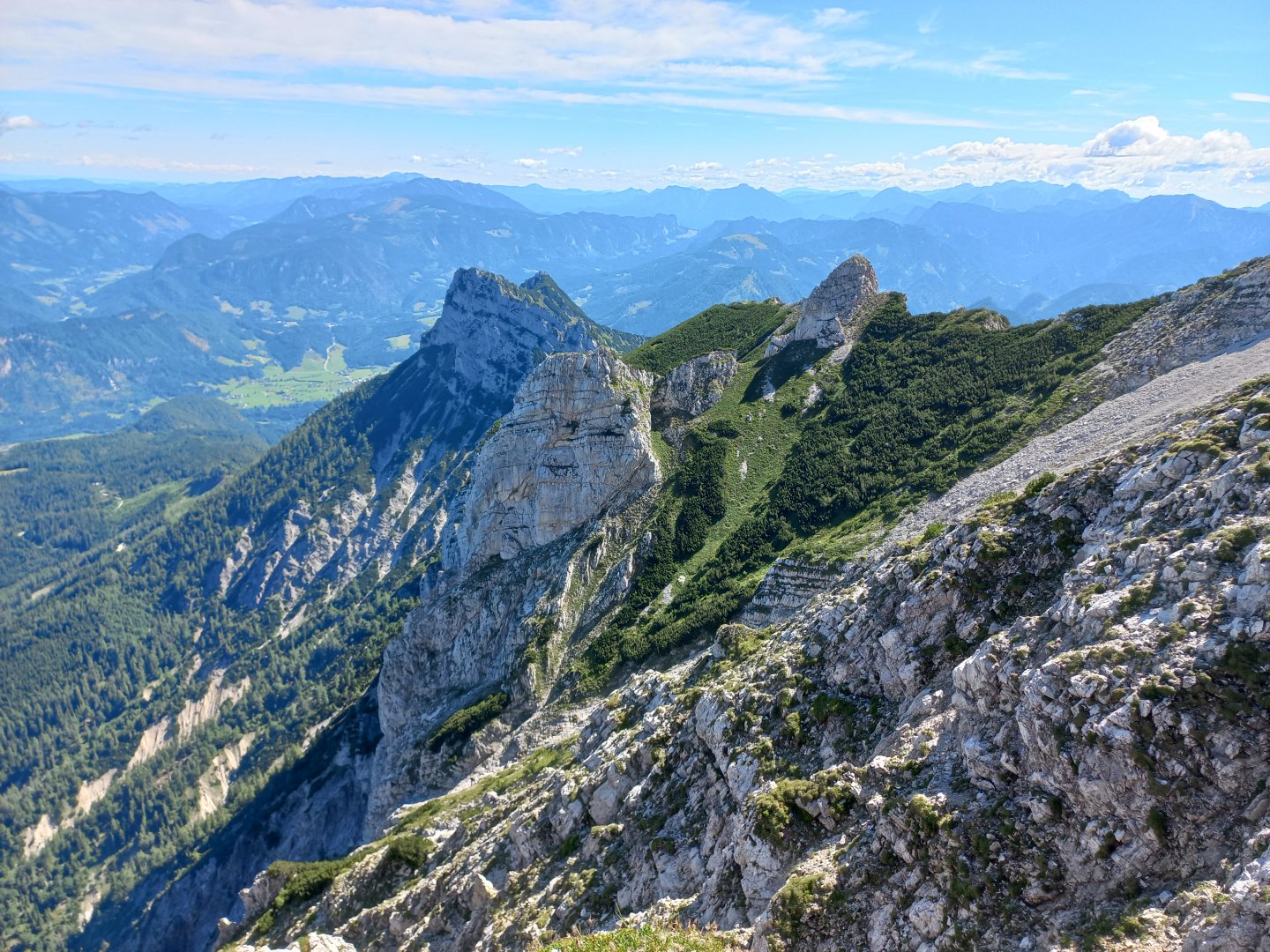
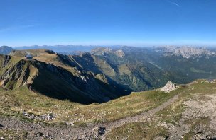
I don't stay long, bypassing the hut and continuing my ascent through the flowering mountain meadows to the top of Tamischbachturm. From the top, a beautiful view of the Ybbstal Alps and the Hochschwab opens up. I am confused by the mountain to the south, from the map I find that it is the Lugauer, which from this viewpoint lacks its typical pointed shape. After resting for a while, I walk down the same path to the hut, where the refreshing Apfelspritz just hisses inside me. A few people are already sitting here, and there are several paths leading to the hut from the valley. The second half of the trail awaits me, not so demanding in terms of elevation, but technically more difficult.
I walk through the sparse forest below the Tieflimauer mountain (1820 m). There are two spurs leading to it from the road - from Teufelskreuz a hiking trail with several secured sections, and a little further on the klettersteig Teufelstieg (C). At Teufelskreuz, I don't meet any cross or devil, but there is a hellish downpour from the black sky. I crawl under a tree in the forest and wait to see how the situation will develop. It thunders three times, litres of water pour out of the sky, but within half an hour it's all over, the summer storm has moved on. I return to the road, the parched ground has absorbed most of the water and the stones are drying quickly, so I continue under the Tieflimauer through the rubble fields to the saddle at Kleiner Buchstein. If you turn around at these points you can see the beautiful, sloping profile of the Tamischbachturm. In the saddle I switch to the other side of the ridge. The quality of the path deteriorates a bit - there are a few steeper spots where you have to use your hands. The path continues on traverses, alternating between grass and rubble. The surface is rough in places, with rocks underfoot in the rubble. Rather unpleasant, however, than posing a greater danger. The traverse ends at the Otterriegel signpost (1485 m).
Here the climb to Kl. Buchstein, which is not far away, but you need climbing equipment to climb it. I head down along the dry stream bed of the Mühlbach, full of whitewashed stones. Later, the stream reappears and collects dozens of smaller streams on its way down the valley, which flow down the mountain after heavy rain. About an hour later I'm back at the parking lot. On the way back, I stop at the medieval castle of Gallenstein (Burgruine Gallenstein) above the town of Sankt Gallen. The stone castle is freely accessible and from its galleries you can see all three peaks I've walked around - Tamischbachturm, Tieflimauer and Kleiner Buchstein.
Difficulty
The Gesäuse National Park lies on the tri-border between the three Austrian states of Upper Austria, Lower Austria and Styria. Among the many hiking trails, I chose a circular trek below Groβer and Kleiner Buchstein and a climb up a mountain with an interesting, sloping profile - Tamischbachturm (2035 m). The whole route is on marked AV trails and is more demanding in terms of elevation and distance. However, there are more hiking trails around, it is possible to shorten, lengthen or spread over two days with an overnight stay at the Ennstaler Hütte. There are several trails leading to Tamischbachturm from the valley, the Alter Steig via Buttensattel is interesting, but it is steep, unmarked, with a few easier climbing sections below the summit.
Water availability
Refreshments are available at the Ennstaler Hütte, there is a stream at the beginning and end of the route.
Sleeping options
Overnight stays are possible at the Ennstaler Hütte or in guesthouses in the valley.
Mountain peaks
Ascent to Tamischbachturm 2 035 m above sea level, views of Gr. and Kl. Buchstein, Hochtor, Admonter Gruppe, Lugauer, Hochschwab, Ybbstal Alps.
Danger
The trail is not dangerous for the most part, the most care must be taken when going around the Tieflimauer mountain. It is on a rubble field, the stones are loose. It is necessary to have a firm step. In some places it is necessary to use your hands to make the going easier.
Food
Refreshments are only available at the Ennstaller Hütte, it is necessary to have some snacks with you.