Mountain range, region / State
Ennstal Alps / Austria
Season
Winter
25. 02. 2024
Difficulty
2 / 5
Elevation
↑ 660 m
↓ 660 m
Length
10.4 km
4 hours
Altitude
max. 1492 m n.m.
min. 974 m n.m.
Tips for hikes in the mountain range Ennstal Alps

Climb to the top of Scheiblingstein in the Ennstal Alps
Climb to the Eisenerzer Reichenstein from the Präbichl saddle
Climb to the Groβer Pyhrgas mountain
Winter trek to Mount Wasserkogel
Starting point
Free parking in the Hengstpass, approx. 10 km from Windischgarsten (A9 motorway to Graz).
Description of the hike
I leave my car in the Hengstpass saddle in the free parking lot at the Zickerreith Inn. There are more parking lots in the saddle, but they tend to fill up early, Hengstpass is the starting point of routes to different directions.
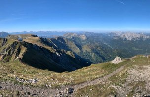
The gravel path climbs gently from the inn to the nearby Kreuzau plateau. After just a few metres, the snow-capped peaks of the two-thousanders peek out from behind the opposite hill. These are the Haller Mauern - Kreuzmauer, Scheiblingstein and Kleiner Pyhrgas from the left, overlooked by Grosser Pyhrgas. Beyond the meadows of Kreuzau, the road plunges into the forest and skirts the rounded hill of Zeitschenberg on the right. The view to the right shows the perfect peak of the Astein and in the distance the Gesäuse mountains can be seen in the gap between the other hills. After about an hour's drive I come to the Dörflmoaralm cottages. Here the path splits, to the left goes the trail to Windischgarsten, to the right goes the Wasserklotz. In the distance you can see the Totes Gebirge, from Warscheneck to Grosser and Kleiner Priel.
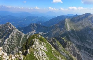
I put on my snowshoes and continue through the pastures to the Astein - Wasserklotz ridge. Here it is possible to choose one of two ascent routes - from the west or from the north. The paths are only a few hundred metres apart, forming a sort of loop around the summit. There is about half a meter of snow on the plain, so I choose the route via Westgrat, the western ridge, because it is better trodden by ski mountaineers and hikers with snowshoes. It starts with a steep climb through a beech forest (about 200 vertical metres). I don't see any signs, I stick to the beaten track. The signpost at the bottom of the meadow in Ahornsattel points to a 50-minute climb to the top, but the snow makes the ascent a bit difficult. There is no avalanche danger here among the trees. To the west, the Dürrensteigkamm ridge from Almkogel to Bodenwies is visible. Finally, from the shadow of the north side, I reach the ridge, where the sun is beautifully warming. The summit of the Wasserklotz is already clearly visible from here, it's just a few minutes straight along the ridge between wind-swept trees and kneeling. The top of the Wasserklotz at 1505 m is decorated with a simple wooden cross. The views are fantastic - the aforementioned Haller Mauern and Hexenturm to the south, Pyhrgas, Totes Gebirge to the west, Sengsengebirge, Dürrensteigkamm to the north, Ötscher, Ybbstaly, Hochschwab, Grosses Maiereck, Gesäuse - the sloping Tamischbachturm, Tieflimauer, Kleiner and Grosser Buchstein in the distance to the east.
I still want to try to see Astein from this side, the unmarked trail descends slightly right along the ridge. On Astein there should be a metal cross on a rock, but the path is not trodden any further, I am struggling a lot in the fresh snow. According to the map I am standing just below the top, but there are more rocks, I can't see the cross and everything is under the snow, I don't want to claw up. I can't find the unmarked descending path either, so I return the same way I climbed back. Down below, the snow is melting a lot in the midday sun, the grass is showing on the hillsides and the snow roses are blooming on it. Even the path around the stream is not trodden, and so I return again via Dörflmoaralm and Kreuzau to Hengspass.
Difficulty
The climb to the Wasserklotz (1505 m) is an easy half-track that can be done at any time of the year. Most of the route follows wider forest paths or pastures, only the last part to the summit is steeper but not dangerous. The starting point is the Hengstpass saddle at 1000 m. An alternative for the more challenging is to climb from the west over the next peak, Astein (1419 m), where an unmarked path leads, but beware very steep and necessary to weave between the rocks below the summit.
Water availability
Refreshments are available in the Hengstpass saddle, there are water troughs in the pastures. Be sure to have your own water supply.
Mountain peaks
Climb to Wasserklotz 1 505 m above sea level and Astein 1 419 m above sea level. Views are of Haller Mauer, Grosser and Kleiner Pyhrgas, Totes Gebirge, Dürrensteigkamm, Gesäuse, Ybbstal Alps.
Danger
The trail follows marked routes, it is not dangerous. Avalanches are not a threat in winter, most of the ascent route is in the forest.
Food
Refreshments available at the Zickerreith Inn at the start/end of the tour. It is good to take some snacks with you.


