Mountain range, region / State
Ennstal Alps / Austria
Season
Summer
12. 08. 2023
Difficulty
3 / 5
Elevation
↑ 1366 m
↓ 1366 m
Length
13.2 km
6 hours
Altitude
max. 2244 m n.m.
min. 1023 m n.m.
Tips for hikes in the mountain range Ennstal Alps

Climb to the top of Scheiblingstein in the Ennstal Alps
Hike to the Wasserklotz lookout in Kalkalpen NP
Climb to the Eisenerzer Reichenstein from the Präbichl saddle
Circular trek to the Groβer Pyhrgas mountain
Starting point
Parking at the former Grosshütte Inn above Spital am Pyhrn (free).
Description of the hike
From the train station in Spital am Pyhrn I go up the narrow road towards Oberweng and then a few hundred metres through the forest to the Grosshütte (former inn). There is a spacious free parking lot next to it. I follow the forest path in the direction of Gowilalm and Grosser Pyhrgas, according to the signpost it should take 4 hours to get to the top. About half an hour along the Forststrasse takes me to the wooden Holzeralm huts, where it is possible to refill water. The Holzeralm lies right at the base of the Grosser Pyhrgas, with the rubble fields starting a little above it.
I continue up the path through the meadow where horses and cows graze to Gowilalm. It's quite busy here, with a wide view of the valley from the cottage. From Gowilalm a path traverses under the Kleiner Pyhrgas slope. The climb is a little more difficult, there are rocks and kneeling roots on the path. The path over the rubble is well marked and supported by larger rocks, it does not slip. Over the edge, I reach the basin between Kleiner and Grosser Pyhrgas and suddenly it's like being somewhere in the Dolomites - more rubble, time-worn limestone boulders and even in August there are remnants of snow. I pass through a cauldron and somewhere in the middle the trail turns right under a rock. Here, a large stone bears the warning "Trittsicherheit erforderlich" accompanied by a few smiley faces, which translates as: from now on, step security is essential, but it will be fun. Nothing to worry about though, the path is well marked and secured in several places with a fixed rope. The rope is not needed at all in dry conditions, I'm more likely to grab rocks. Secured sections are always only a few meters, then the path continues on the grass to the edge of the ridge. The climb is nutritious, one contour after another.
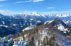
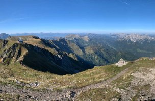
I rest on the ridge for a while and admire the view across the valley to the Totes Gebirge and the opposite Kleiner Pyhrgas, which has a summit at about the same height. I'm at two thousand and still have two hundred vertical metres to climb to the summit. The steep climb and having to stop every few metres to catch my breath makes me wonder whether I'll catch my second wind or my first heart attack first, I'm closer to the latter. But it's also the most beautiful part of the route, with the Haller Mauern - the round Scheiblingstein and the Hexenturm tower looming behind Pyhrgas, the view down into the cauldron is stunning. The summit cross (2,244 m) emerges after the last grassy edge. On the other side, the slope is more glorious, two paragliders have just taken off, a run-up, a few jumps and they are gliding over the valley. I rest here for a while and admire the views - Haller Mauern, Gesäuse, Ennstal, Grimming, the misty Dachstein and Schladmingy, the Totes Gebirge with the striking Grosser and Kleiner Priel and nearby Warscheneck. Bosruck, the huge mountain above Spital am Pyhrn, seems tiny from here, even though it is only 250 metres shorter.
The path down the western edge is not entirely pleasant, winding in serpentines between rocks and kneeling. The surface is not firm - loose rocks slip, stone slabs are crossed, sticks come in handy here. After about an hour and a half, I stumble to the saddle of the Hofalm. There are cows lying in the grass after lunch. A few metres down to the hut, where the view of the Spital am Pyhrn is as clear as day. I slowly sip my homemade elderflower lemonade and after a while of refreshment I walk back along the wide forest path to the parking lot of the Grosshütte.
Difficulty
There are several ascent routes to the Grosser Pyhrgas. The most walked route is the one from the west, from Hofalm. From the south, the slightly more demanding Hofersteig climbs from the Rohrauerhaus hut, and from the north you can reach the summit from Gowilam via the Bad Haller Steig. All ascent routes are marked with a black dot as hiking routes with higher difficulty. There are short belayed sections on the way, but ferrata equipment is not necessary.
Water availability
Water can be refilled at the trailhead from the spring at Holzalm, refreshments at the Gowilalm and Hofalm huts.
Sleeping options
One day trek, I spent the night in the valley.
Mountain peaks
Ascent to Grosser Pyhrgas (2244 m), views of Sengsengebirge, Kleiner Pyhrgas, Haller Mauern, Gesäuse, Ennstal Alps, Grimming, Bosruck, Warscheneck and Totes Gebirge.
Danger
The route leads along marked hiking trails, several sections are secured by a steel rope, there are steep slopes on the route. Sometimes it is necessary to use your hands as a support when crossing the rock steps. The rocks are slippery in places, hiking poles are suitable.
Food
Refreshments are available at the Gowilalm huts at the start of the route and the Hofalm at the end of the route.
Attractions
Grosser Pyhrgas and Bosruck are border mountains. They form a divide between Upper Austria and Styria.


