Mountain range, region / State
Hochschwab / Austria
Season
Spring
06. 04. 2024
Difficulty
3 / 5
Elevation
↑ 891 m
↓ 891 m
Length
15.4 km
6 hours
Altitude
max. 1557 m n.m.
min. 782 m n.m.
Tips for hikes in the mountain range Hochschwab
Trek to Krautgartenkogel in the Hochschwab
A fair mountain climb up the Hochturm
Ascent from the Präbichl saddle to the Hochturm mountain
Spring climb to the Grosser Buchberg
Starting point
Free parking in the village of Hinterwildalpen on the NW side of the Hochschwab.
Description of the hike
The Austrian Hochschwab mountain range is usually traversed in an east-west direction. Popular are also single-track trails with access from the south, where there are huts and almshouses. In the north, the Salza River, known to rafting and canyoning enthusiasts, separates the Hochschwab from the Ybbstal Alps. The starting point from the north is the small town of Wildalpen, or its more remote part Hinterwildalpen (about 6 km).
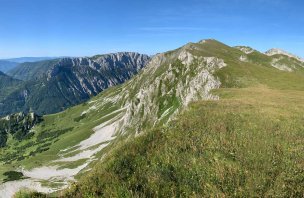
I leave my car in Hinterwildalpen in the parking lot of Gasthaus zum Krug. The inn was closed in April, the parking lot for about 20 cars was completely empty. Just a few steps away is a signpost where I head off to the right, it should take around 3 hours to get to Grosser Buchberg. The signpost leads first along the asphalt road past nice old houses and farmhouses. Shortly after the last of these, it turns into the forest, where it continues along wider forest paths and then narrow footpaths to the Göβ saddle (about 2 hours' walk). In the saddle there is a large cracked stone and a chapel with holy pictures. A beautiful view of the northern part of the Hochschwab, the peaks of Hochstadl, Riegerin, Ebenstein, Brandstein and the nearby Grosser Geiger opens up here.
From Göβ, the road continues up to the Lurghöhe hill with views westwards to Gesäuse - Tamischbachturm, Grosser and Kleiner Buchstein. In the north, you can see the entire route of the Ybbstaler Haute Route, the long-distance route between the peaks of Hochkar - Dürrenstein - Ötscher. Three limestone spires are worth mentioning just outside Göβ. According to the description, they are three tailors who started playing cards here instead of going to Christmas mass. A stranger appeared to them, and when, when asked why they didn't go on, they cheekily replied that they would go when the last pilgrim from Mariazell was returning, he left them petrified on the spot.
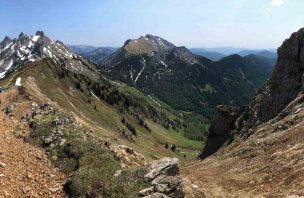
I cross the Lurghöhe meadows to the Gögalalm alm at about 1400 m. There are still remnants of snow here and hundreds of white snow roses bloom in the fallen grass. Behind the alm I can already see the summit of Grosser Buchberg (1563 m). To the left is the massive Kalte Mauer and from it to the west the Eisener Alps with the Kaiserschild massif, the more distant Zeiritzkampel - Leobner and Gesäuse with all the prominent peaks - the pointed Lugauer, called the Styrian Matterhorn, Hochtor, Gr. A Kl. Buchstein.
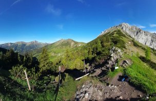
After resting for a while, I set off in the direction of Heimmoseralm. If you would like to extend the route (approx. 23 km, 1300 m elevation gain), you can continue from here on unmarked paths to the top of Grosser Geiger. The path is not officially marked, but according to descriptions on Austrian websites there should be stone men to guide you along the Wassermäurer ridge. From Grosser Geiger back to Hinterwildalpen, the path then follows the marked AV route again.
I descend through Pumperlalm, hidden in the forest, down the Lurggraben canyon. The Lurgbach stream cascades through the canyon. The limestone here has eroded into spires and deep grooves carved into the Lurgmäuer wall. From the game preserve with the deer feeders, a wide forest path leads me back to Hinterwildalpen. The whole route takes about 5-6 hours.
If you don't want to do that, you can see the Grosser Buchberg and Lurghöhe from the nearby Hochkar (1808 m). It takes about a quarter of an hour to drive to the village of Lassing and from there take the Hochkar Alpenstrasse (toll in season) to the parking lot of the ski resort at about 1600 m. I described the summer Hochkar earlier on NaTrek, it's an easy climb of about an hour from the car park to the top with an elevation gain of about 200-300 m, possibly on pistes. In addition to the view from the top, you can also enjoy the 360° Skytour suspension footbridge.
Difficulty
Grosser Buchberg (1563 m) is an unassuming peak in the foothills of the Hochschwab, but with beautiful views of the surrounding mountains. The route mostly follows marked hiking trails, there are no exposed places. The climb is of course more challenging, due to the remnants of snow, which can break up and become wet in spring.
Water availability
There is no hut on the road, there are streams along the way, and water buckets at the almshouses. There are inns in Hinterwildalpen and Wildalpen.
Sleeping options
There is no hut on the route, plenty of accommodation in the valley.
Mountain peaks
Ascent to the summit of Grosser Buchberg 1 563 m above sea level, views of the Austrian mountains Hochschwab, Eisenerzer Alpen, Lugauer, Hochtor, Gesäuse, Ybbstal Alps.
Danger
The route leads along footpaths or forest paths, most of which are marked (AV).
Food
There is no hut on the route, refreshments are available in HInterwildalpen or Wildalpen.
Attractions
Wildalpen, a picturesque town on the banks of the Salza (rafting, canyoning)
Wasserlochklamm - a gorge with waterfalls about halfway between Wildalpen and Palfau
Hochkar, ski resort, 360 Skytour viewpoint
Mendlingtal - adventure trail (Erlebnisweg) near the village of Lassing
Photos


