Mountain range, region / State
Rottenmann and Wölz Tauern in Alps / Austria
Season
Summer
26. 08. 2023
Difficulty
2 / 5
Elevation
↑ 723 m
↓ 723 m
Length
8.8 km
5 hours
Altitude
max. 2220 m n.m.
min. 1584 m n.m.
Tips for hikes in the mountain range Rottenmann and Wölz Tauern in Alps

Climbing the Schoberspitze in the Wölzer Tauern
Trek to the Hohenwart in the Wölzer Tauern
Circular tour through Grosser Bösenstein in the Low Tauras
Trek to Hochrettelstein in the Rottenmann Tauern
Starting point
The Planneralm ski resort, which is accessed by a high mountain road. No toll.
Description of the hike
We arrived at the Planneralm resort late in the evening and set up our tents by a small reservoir in front of the resort. After the overnight rain the weather was better in the morning, but the clouds in the west looked ominous. The forecast again threatened thunderstorms after lunch and so we set off for the mountains early in the morning.
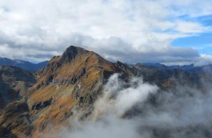
We passed through the Planneralm resort and started climbing up the trail to the Plannersee lake. The climb is not difficult, we soon found ourselves amongst the slash and burn and soon reached the lake. After a short rest we continued on the trail to the ridge. Here the trail climbed quite steeply. In the hot saddle we rested again for a while. Unfortunately, the weather started to turn bad and soon a cloud surrounded us. The next journey beyond Horchrettelstein was thus without views. The trail at the beginning runs almost horizontal. Only in the second part does it start to climb. Surrounded by clouds, we climbed to the top of Hochrettelstein. Occasionally the clouds broke and we could see the surrounding mountains.
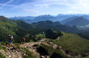
After a rest and a snack we started to return. We walked up to the Plannerknot saddle still in the clouds and were determined to take the shortest way down to the car. However, the clouds disappeared in no time and fantastic views of the surrounding area opened up. We therefore decided to continue along the ridge to the top of Plannereck. The trail was quite rocky. Soon we reached the top of Mount Plannereck. We continued along the trail to the top station of the lift. Here we left the trail and continued on the downhill slopes. Partly on the path and through meadows we descended to Planneralm, where we had a meal and a drink in the pub. Then we returned to the car in the car park.
Difficulty
Thanks to the high altitude of the Planneralm, this is an easy alpine hike. The altitude is not too high for the Alps. The whole time you walk on mountain trails. The trail to the Plannereck is very rocky, sometimes you have to use your hands. Children or dogs can also manage the route.
Water availability
There are a lot of streams in the Plannersee Lake area, but there are cows grazing, so we only drank water from our own bottles. It's good to have 1.5 litres per person.
Sleeping options
We spent the night before the trek in tents in front of the resort. Otherwise, there are several accommodation options in the resort itself.
Mountain peaks
On the route we climbed to the top of Hochrettelstein 2 220 m above sea level and Plannereck 2 003 m above sea level. You can see the whole Rottenmann Tauern, Dachstein, Schladming Tauern and others.
Danger
The route is simple. It is a classic alpine trek. The mountain paths are a bit more rocky in places, so they can be slippery when wet. Otherwise, there is no exposed or airy spot on the route.
Food
There are several restaurants in the Planneralm. We also used one after we returned from the trek. We had our own snacks and some sweets for the trek itself.
Photos