Mountain range, region / State
Mürzsteger Alps / Austria
Season
Winter
28. 01. 2024
Difficulty
2 / 5
Elevation
↑ 871 m
↓ 870 m
Length
14.6 km
6 hours
Altitude
max. 1697 m n.m.
min. 1229 m n.m.
Tips for hikes in the mountain range Mürzsteger Alps
A leisurely trek to the Windberg in the Schneealpe mountains
Winter hike in the Schneealpe mountains
Crossing the Grosser Wildkamm
Winter ascent of Mount Tonion on snowshoes
Starting point
The Niederalpl Pass road saddle, located north of the Hohe Veitsch mountain massif.
Description of the hike
I leave my car in the free parking lot in the Niederalpl saddle. It's eight in the morning, the lifts don't start running until nine, so the car park is still completely empty, and it's hard to find a space later. The slopes are smooth in the morning, groomed with a corduroy snowmobile, so I put on my snowshoes and head straight up under the lift. The sun swings over the opposite nearly two-thousand-foot massif of the Hohe Veitsch and Wildkamm mountains and begins to warm pleasantly. On the slopes of the Wetterin mountain I reach the Wetterl saddle and from there continue along the marked trail towards the Weiβalm. The snow is frozen over, but the path is climbed, so it goes well.
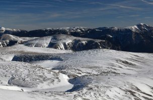
In less than an hour I reach the small alm Weiβalm, where the road turns to the right. There are no signs here, everything is under snow, but you can follow the wooden crosses. The route follows the pilgrimage trail to Mariazell and there are crosses and monuments at every fork. I continue through the snow-covered meadows below the Brachkogel, descend to the Halterhütte hut and climb again along the beaten track through the forest to the Herrenboden plateau. The smoothly blown plain shines in the sun, the small houses are half covered with snow. I walk towards the horizon, where a modern statue of the Madonna stands at a crossroads.
The views open up to the east, you can see Göller and Raxy. From the Madonna, the tracks turn left, the trail passes through a trough between the Schneekogel and Hochschnäbelkogel hills. Beyond the edge, it then follows the contour line between terrain undulations further up. If there weren't tracks here I'd be lost, there's about a metre of snow and no signposting. The summit of Tonion (1699 m) appears only at the last moment. The circular view is fantastic - Hohe Veitsch to the south, the Hochschwab to the west, the Ybbstal Alps, Gesäuse, Dürrenstein, Ötscher, Göller, Gippel to the north, Schneeberg, Windberg, Raxy and Stuhleck with the windmills to the east. I rest and bask in the sun. One could sit here and watch all day, I just don't like to get up to leave. I'm tempted to continue down the other side, crossing the entire ridge on the marked trail to the valley road, but I haven't figured out transportation back, so I return the same way. I meet a few ski mountaineers and, down at Herrenboden, other snowshoers. A beautiful route that I will definitely repeat sometime.
Difficulty
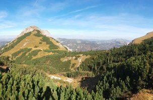
The Tonion is a distinctive rocky massif standing between two Austrian mountain ranges - the Hochschwab and the Rax. The ascent is not difficult, however; the marked AV route circumnavigates the mountain on meadows and pastures from northwest to southeast. The easiest ascent starts at the Niederalpl Pass (1212 m), where there is also a small ski resort. In winter, it is a popular Winterberg for ski mountaineers and snowshoers.
Water availability
Mountain peaks
Climb to the Tonion, circular view from the south clockwise Hohe Veitsch and Wildkamm, Hochschwab, Ybbstal Alps, Gesäuse, Mariazellerland, Dürrenstein, Ötscher, Göller, Gippel, Schneeberg, Windberg, Raxy, Stuhleck (windmills).
Danger
The path is not dangerous, but in winter you can't see the markings, I walked on the beaten path from the skialps/snowshoes.
Food
Food is available in the Niederalpl road saddle or to go.


