Mountain range, region / State
Salzkammergut / Austria
Season
Fall
24. 09. 2023
Difficulty
3 / 5
Elevation
↑ 1217 m
↓ 1217 m
Length
13.5 km
7 hours
Altitude
max. 1030 m n.m.
min. 428 m n.m.
Tips for hikes in the mountain range Salzkammergut

Hiking up the Drachenwand wall in the Salzkammergut
The challenging crossing of the Schrottkamm ridge to Bad Ischl
Hike to Mount Sandling in the Salzkammergut
Viewing route from Traunkirchen over Lake Traunsee in the Salzkammergut
Starting point
Traunkirchen, a car park a short walk from the centre (free parking on the hill, Kurzparkzone on the lake shore - time-limited and chargeable, but also free on Sundays).
Description of the hike
I arrive in Traunkirchen from Gmunden, leaving my car in a parking lot a short distance from the centre. In the morning the town is still crowded, so I take advantage of this and go sightseeing first. The dominant feature of the town is the parish church of the Coronation of the Virgin Mary. Next to it on the hill stands the Johannesberg Kapelle, a chapel dedicated to John the Baptist. From the small marina you can see the first peak of the trip - the Kleiner Sonnstein rock (923 m).
Following the marked trail I climb up to Kalvarienberg. But there is one more surprise waiting for me - Villa Pantschoulidzeff, or Russenvilla. The villa was built in the second half of the 19th century and became the summer residence of the Russian noblewoman Sophie Pantschoulidzeff. Even the scratched plaster and dilapidated shutters do not detract from the beauty of the house, and the extravagant garden decoration will take your breath away. There are chubby little angels, a soldier wearing nothing but a helmet, statues of wild animals and a huge two-metre high pyjama towering up to the sky. The decadent collection teeters on the edge of art and taste, but I like it, the Russian Villa has style.
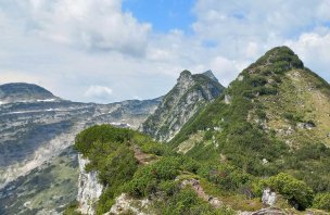
I continue on to the Baroque Calvary hidden in the forest. After it, the path turns left and goes around the hill along the contour. Not many people seem to walk here, the path is barely noticeable in places, there are fallen trees. I continue in the green gloom of the forest, admiring the nooks and crannies covered with clumps of smooth ferns, gullies with mossy rocks and wild potato plants that bloom right by the path. After an hour or so, I come across the Siegesbach stream, which flows in cascades and waterfalls to the Traunsee below the cable car. The path is now more narrow, rocky, and in places supported by wooden steps. I climb up to the Ludleben saddle. Here I turn left to Kleiner Sonnstein. The last metres to the Sonnsteinhütte are more difficult, over rocks, but nothing dangerous, even with children and dogs. From the saddle there are views across to the Ebensee. The hut is tiny, nestled in a hollow between the rocks like a nest, and it is only a few metres to the wooden cross at the top.
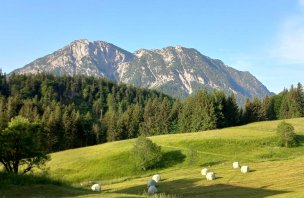
The view is fantastic - the blue lake with the boats, the Traunkirchen peninsula and especially the mighty Traunstein, whose peak is still hidden in the clouds. After a rest I return to the saddle and continue on to Groβer Sonnstein (1037 m). The path goes under the rocks and just below Gr. Sonnstein is divided into a climb with a secured section and an easier option. However, the belayed section is short and easy and within a moment I am at the summit cross. Here too there are perfect views - back to Kleiner Sonnstein, Traunstein, the opposite Erlakogel and the town of Ebensee. To the south and east, the Schrottkamm ridge above Bad Ischl disappears into the clouds, followed by the Totes Gebirge. To the west, the Feuerkogel with its cable car and ski resort can be seen.
From the crossroads I return to Traunkirchen along a wide forest path. After about an hour, I turn to the Geiβwand (872 m). Below the summit there are a few meters secured with chains. Traunstein is almost within reach. From the neighbouring Baalstein (800 m) there is again a wide view of the flat landscape near Gmunden. From Baalstein there is a steep descent down a serpentine path to the wider Zellerweg, which leads me back to the Calvary, Russenville and the town.
Difficulty
Traunkirchen is a small town on the banks of the Traunsee, one of the most photographed in Austria. You will find a picture of the church on the rocky outcrop, the blue lake and the Traunstein massif behind it in every brochure of the Salzkammergut and Upper Austria. But the tourists stay down by the lake, just a few dozen metres higher up you won't meet many people and enjoy a wonderful scenic route. Most of the route follows marked hiking trails or a wide forest path/bike path.
Water availability
Refreshments in Traunkirchen or at the mountain hut on Kleiner Sonnstein.
Sleeping options
The area around Lake Traunsee is a tourist destination, with everything from campsites to luxury hotels.
Mountain peaks
Výstup na Kleiner a Grosser Sonnstein a skalky Geisswand a Baalstein. Výhledy na Traunstein, Totes Gebirge, Hohe Schrott a Höllengebirge (Feuerkogel).
Danger
The route is not dangerous, there are a few easy, safe sections on the ascent to Groβer Sonnstein and Geiβwand. Otherwise, there are forest paths, which are sometimes more overgrown.
Food
Refreshments are available in Traunkirchen or at the Sonnsteinhütte on the Kleiner Sonnstein mountain.
Attractions
You can find more about Traunkirchen on Wikipedia - de.wikipedia.org/wiki/Traunkirchen


