Mountain range, region / State
Schladming Tauern / Austria
Season
Summer
31. 08. - 03. 09. 2023
Difficulty
3 / 5
Elevation
↑ 3778 m
↓ 3008 m
Length
32.8 km
4 days
Altitude
max. 2858 m n.m.
min. 1074 m n.m.
Tips for hikes in the mountain range Schladming Tauern
Round trip in the Schladminger Tauern with ascent to the Grosses Gurpitscheck
Hike around Hochgolling in the Schladming Tauern
Circular trek in the Schladming Tauern
Trekking in the Schladming Tauern
Starting point
The trek starts at the parking lot of Riesachfall Wilde Wasser. This parking lot is paid. There is a direct bus from Schladming.
Description of the hike
1. day
On the first day we set off from the Schladming train station, took a bus to the car park at Riesachfall Wilde Wasser, from there we walked to Gollinghütte. The walk started as a dirt road and it lasted almost all the way to the hut where we were staying. Accommodation must be booked in advance on the website, the cheapest accommodation per head costs about 25 Euros.
2. day
The next day we went to the top of the Hochgolling mountain (2862 m). But first we had to pass through the beautiful Gollingwinkel valley, which ends in front of the Hochgolling. From that point on we climbed steeply up to the Gollingscharte saddle, where we had a longer break, but then we turned left and again climbed steeply to the summit. This part is not recommended for the inexperienced, in places it would require chains and ropes, which unfortunately are nowhere to be found on the ascent. We didn't reach the top though, due to lack of time. We ended up at about 2700 m above sea level. At that point, we turned down and descended back to Gollingscharte, and started heading towards the next overnight stop (Landawirseehütte). We descended into the Göriachwinkel valley and then climbed up to the hut. The night cost us about 23 Euros. Reservations are required.
3. day
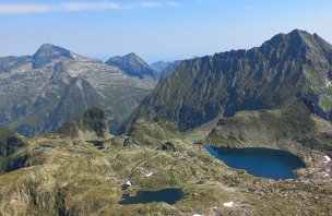
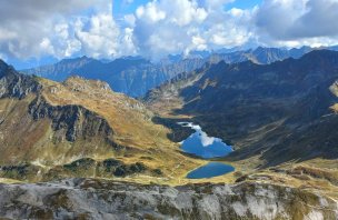
On the third day we had the longest march, crossing over two ridges. The first ridge was just above the hut, Trockenbrotscharte. From then on we descended to the Keinprechthütte hut. We encountered some light ferrata on the way, nothing dangerous, and we took a break at the hut because the most challenging section awaited us, a steep climb up to the Rotmandlspitze mountain. The views from the mountain were breathtaking, however time was against us and we had to descend to the Unterer Giglachsee lake. The descent down the mountain was somewhat unpleasant, quite steep terrain. It was only about 15 minutes from the lake and we were at the hut, where we were told they had a capacity problem (despite the reservation) so they sent us back to the lake again, where we were put up in another hut where there was hardly anyone and it was quiet. Except that you can't get a reservation for this cottage, it is a family cottage where the father of the cottage owner, Ignaz-Mattis-Hütte (the original accommodation) lives.
4. day
On the last day we had a ridge run up to Hochwurzen, we wanted to enjoy the views on the way, but the fog was so thick that we could only see a few meters. We extended our journey to cross the Hochfeld mountain, where fortunately we could see something. After that, we were practically descending, with more people just walking from the cable car. We also saw trees for the first time in four days. We finished our journey on the Kleine Hochwurzen mountain, enjoying the last views until the cable car to the lower station came. From there we took the bus from the Hochwurzen Gipfelbahn Talstation stop to Schladming.
Difficulty
The trek was challenging in places, mainly due to the paths over the fallen rocks, where the path was formed as needed. There are all kinds of paths on the trail - forest paths, gravel paths, steps, stones, footbridges. The route was manageable without any climbing equipment. Above 2500 m..altitude we felt a slight headache.The descent from Rotmandlspitze towards Ignaz-Mattis-Hütte, was very steep, but we descended without much trouble. There is water running over the paths on the way, where it is a bit slippery. The route is not suitable for children. We brought our hiking boots, raincoat, jacket, food, water, change of clothes.
Water availability
We had 3 litres per person for each day. Water can be replenished from smaller streams, at the cottages. At higher altitudes it is not necessary to filter the water.
Sleeping options
It is forbidden to sleep outside in the Austrian Alps, so it is necessary to book accommodation in advance. (each state has different rules, usually camping is allowed above the forest line) There are four huts on the route: the Gollinghütte, Landawirseehütte, Keinprechthütte, Ignaz-Mattis-Hütte.
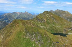
Mountain peaks
The route leads over the peaks of Hochgolling, Rotmandlspitze, Hochfeld. The views are of the Schladming Tauern and other surrounding mountains.
Danger
Occasional terrain can scare but nothing dangerous. The descent from the Rotmandlspitze mountain was unpleasant. The climb up the Hochgolling was equally challenging.
Food
Food can be bought at the huts. But we wanted to save money, so we cooked on our own cooker, instant soups, pasta, rice, beans.
Attractions
There are countless beautiful views along the route, with the Hochgolling mountain being the highest point in the area. The Riesachfälle waterfall can be seen at the start of the trail.


