Mountain range, region / State
Schladming Tauern / Austria
Season
Summer
12. 09. 2021
Difficulty
3 / 5
Elevation
↑ 1298 m
↓ 1297 m
Length
13.1 km
6 hours
Altitude
max. 2471 m n.m.
min. 1599 m n.m.
Tips for hikes in the mountain range Schladming Tauern
Four-day trek in the Schladming Tauern region around the Hochgolling mountain
Round trip in the Schladminger Tauern with ascent to the Grosses Gurpitscheck
Hike around Hochgolling in the Schladming Tauern
Schladming Kalkspitze with spectacular views of the lakes
Starting point
Ursprungalm, an alm accessible by car or by talerbus on the road from Preunegg outside Schladming. There is a toll here.
Description of the hike
The Schladming Tauern is a subgroup of the Low Tauern, which stretches between the mountain resorts of Obertauern, Radstadt, Schladming and the Sölkpaß. The Schladmings are beautiful, sharp mountains with many lakes that offer calendar-like views of the opposite Dachstein, the Ennstal Grimming and the Low and High Tatras. The highest mountain is the Hochgolling (2,862 m), other prominent peaks are the Hochwildstelle (2,747 m) and the remotely visible tip of the Höchstein (2,543 m).
The advantage of the Schladming Tauern is the good access from the side valleys, which are accessible by car, or in summer from Schladming by talerbus. The peaks above Schladming and the neighbouring villages of Preunegg and Haus im Ennstal are also reached by cable cars with winter and summer operation.
At the beginning of September I decide to trek from the Preunegg valley to the limestone peak of Lungauer Kalkspitze (2 471 m). I turn off the Enstal road at the village of Pichl towards the Preunegg Jet lift and continue along the long, steep valley along the Preuneggbach stream towards the Ursprungalm to the toll gate.
It's around 7am, there's no one in the tollgate yet, so I continue along the gravel road through the valley. After a while, the road narrows and climbs higher and higher. I pray that I don't meet a car in the opposite direction, there is not much room, I gradually downshift to second and in some of the switchbacks to first.
Just when I think the road is going to pull me up to the sky, a spacious parking lot appears at about 1600 m.a.s.l. I park and change into my trekking gear, after a while a young man in a Land Rover arrives and I still can't escape the toll. So at least a nice smile, a wish Schönen Tag und gute Wanderung.
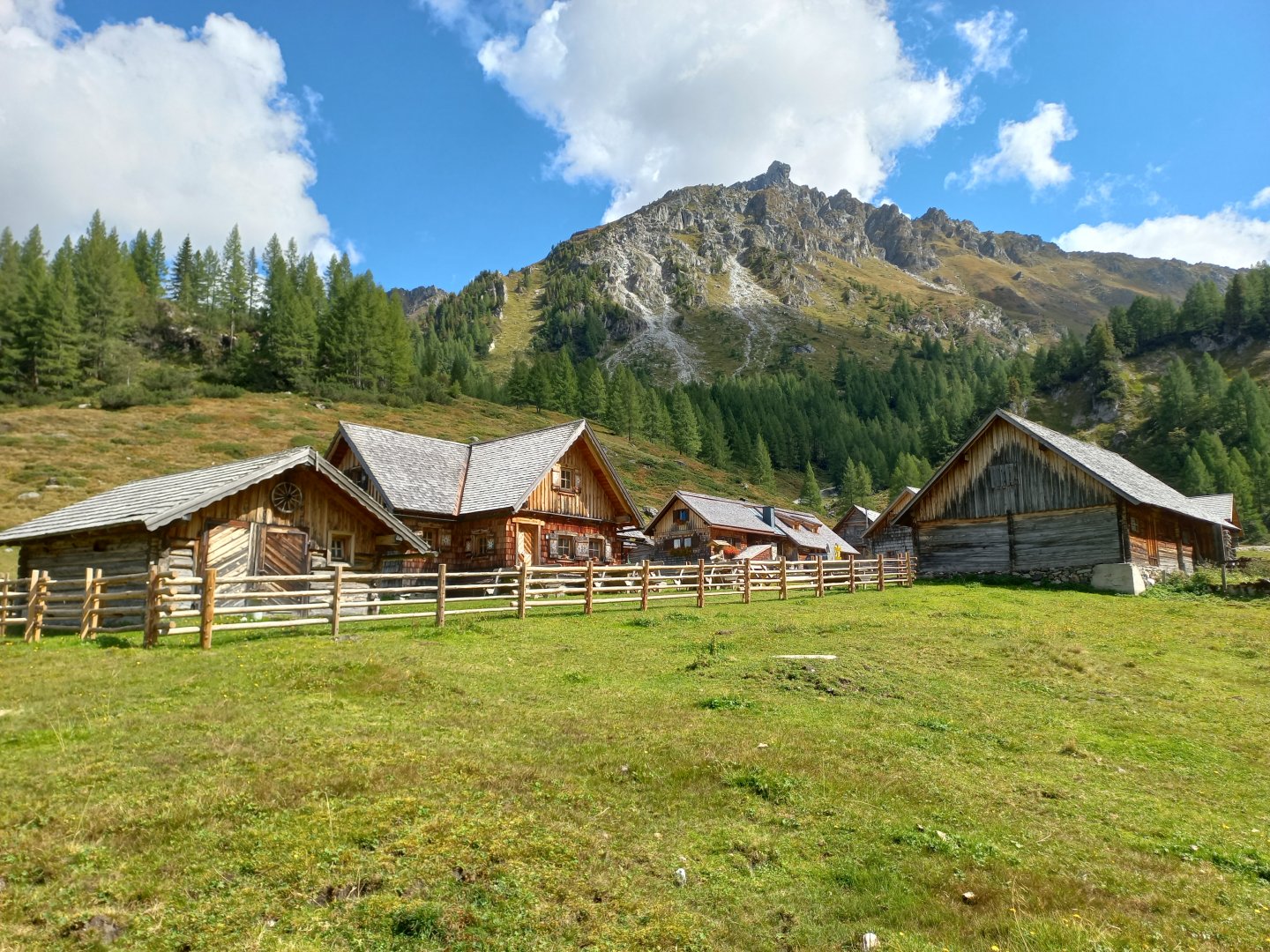
A few metres above the car park, a scene straight out of a movie appears - wooden alm cottages with painted shutters, a babbling brook, blue pools, grazing cows, rabbits running between the houses. I set off along Wanderweg 37 towards the Brotrinnl saddle (2 088 m). I climb over rocks and roots, cross the stream several times, respectfully passing grazing cows. After a while, I reach the knees and rocks and the first views back to the alm appear. The neighbouring Dachstein should be visible, but today it is hiding in the clouds.
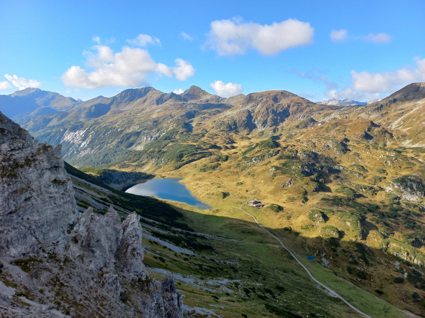
In the little hamlet of Brotrinnl the sign turns to Steirische Kalkspitze, but I am attracted by the next valley with the Oberhütte hut and the lake of the same name Oberhüttensee.
From the saddle I can see the mountains around Obertauern, and I can make out the lifts and slopes of the mountain resort. In the clouds behind Obertauern, the glaciers of the High Tatras shine through, I estimate the three-thousand-foot Hochalmspitze.
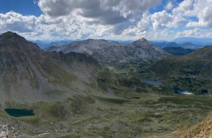
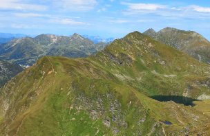
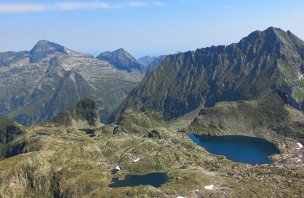
The trail descends sharply, the gravel slipping underfoot, but luckily I'm soon down and heading for a lake that mirrors the surrounding mountains. I go around the hüttenkreuz, past the lake to the signpost towards Lungau. Above me, I can already make out the white oblong massif of the Lungauer Kalkspitze.
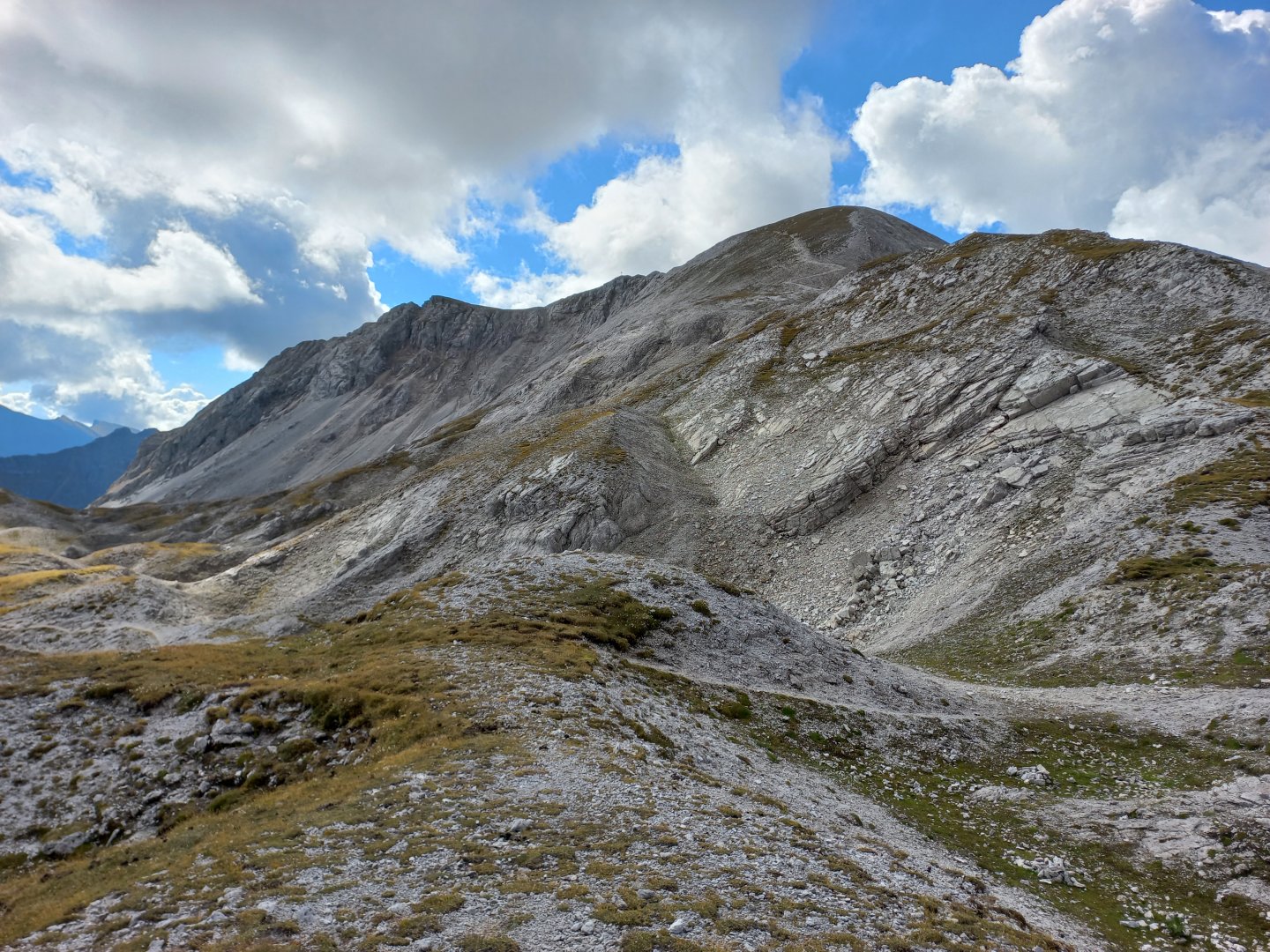
Sheep with jingling bells make the hour-long climb, but they run away, not wanting to be photographed. I reach the next Ahkarscharte saddle and have a dilemma - to the right the original destination Lungauer Kalkspitze (2 471 m), but to the left the equally beautiful Steirische Kalkspitze (2 459 m). The same problem is solved by a nice pair of Austrians coming from the other side of Giglachsee.
We talk for a while, I opt for the originally intended Lungauer, the Austrians for the steeper Steirische Kalkspitze. So I climb the Lungauer Kalspitze comfortably and on the way I observe how the Austrians are doing on the opposite ridge, it doesn't look difficult. After about half an hour, I reach the steep summit ridge and head for the cross.
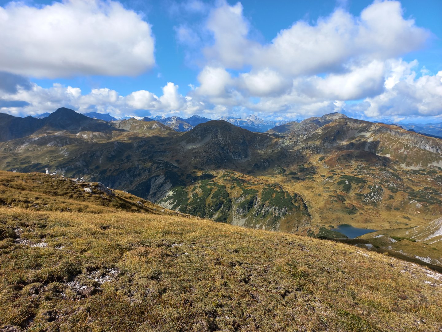
Incredible views - the Giglachseen lakes glistening below, the Hochgolling massif rising up, the Hochwildstelle even further behind. To the west, beyond Obertauern and the three-thousanders with the glacier are already more visible. I sit for a while, take photos, replenish my energy and look for the Austrians on the neighbouring mountain, they are already on the summit.
I descend down and just can't resist, I also run up the Steirische Kalkspitze. Up from the cross I can see the direction of the morning ascent and part of the Ursprungalm, only Dachstein still refuses to emerge from the clouds.
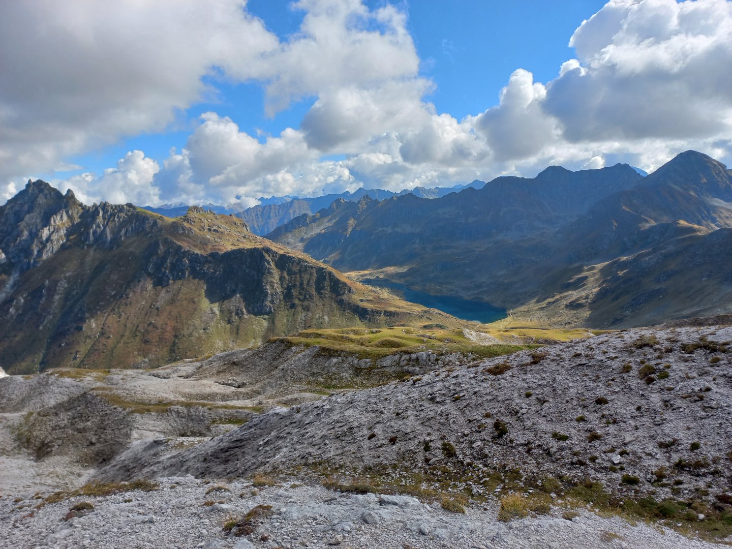
I descend back to the saddle and head over the terrain ripples towards the breathtaking Giglachsee. The lakes change colour as the sun hits them through the clouds, reflecting the surrounding mountains. I head for the Giglachseehütte on the shores of Obere Giglachsee, and a little further on I can also see the Ignaz-Matis-Hütte above Untere Giglachsee. I'm already meeting a lot of people here - the path around the lakes is a popular hiking spot, especially for families with small children, and there's also a bike path for mountain bikes and e-bikes.
I descend the wide path back to the Ursprungalm and the parking lot. I arrive at the parking lot around 2 o'clock, 6 hours on the road, having pedalled about 13 km and 1200 vertical metres.
Difficulty
Classic alpine trek, first through forest, then grass, gravel ascents/descents, no climbing. Marked path. Medium difficulty.
Water availability
Streams or lakes, refreshments at the Oberhütte huts and the huts at Giglachseen.
Sleeping options
Overnight stays are possible in the open air or at the huts along the way - Giglachsee Hütte and Oberhütte am See.
Mountain peaks
The route leads over the peaks Lungauer Kalkspitze 2 471 m above sea level and Steirische Kalkspitze 2 459 m above sea level. The views are great not only of the Schladming Tauern, but also of the Dachstein or the High Tauern.
Danger
The route leads along marked mountain trails. There is no dangerous section, even the ascent to both peaks is trouble-free. It is a good idea to keep your distance from the grazing cows, which have been responsible for several attacks on hikers.
Food
Both cottages on the route cook. So you just need to have some small supplies of your own - bars, fruit, etc.