Mountain range, region / State
Dachstein / Austria
Season
Summer
26. 08. 2023
Difficulty
3 / 5
Elevation
↑ 1937 m
↓ 1939 m
Length
18.7 km
9 hours
Altitude
max. 2667 m n.m.
min. 1136 m n.m.
Tips for hikes in the mountain range Dachstein
Trek across the Kufstein and Kleiner Miesberg mountains near Dachstein
Improvised crossing over the Großer Donnerkogel
Easy climbing the mountain of Stoderzinken in Austria Alps
Starting point
Ramsau am Dachstein - Kulm, Parking under the hotel Feistererhof, payable (3 € per day).
Description of the hike
I park my car in the spacious paid parking lot (3 €) in Ramsau - Kulm, near the Feistererhof Hotel. The Königsetappe starts right at the car park and I will walk part of the way along it. The start of the route is along a wide forest path to the Lärchbodenalm, a small almo with refreshments, about an hour's drive from the valley. From there the path winds between rocks and kneels, still up along the dry Feisterbach riverbed to the lower station of the Guttenbergerhaus hut supply cable car. I pass under the Fischermauer wall and avoid three sheep that have wandered away from the flock. Above me is the Tiefkar cauldron and the round face of Mount Sinabell. I climb further to the Guttenbergerhaus, the only hut on the path.
I leave Königsetappe and turn left towards Gruber Scharte. Traversing under the Eselstein mountain I am there in about half an hour. At Gruber Scharte I stand in amazement - the landscape completely changes character, from grassy meadows to moonscape. The path continues over a rocky plateau, through rubble fields around the rocks. Only small snow fields and snow pits lighten the monotony of grey. At first glance the landscape is completely dead, devoid of grass and other vegetation, but beautiful in its rawness. At Gruber Scharte, the Ramsauer Höhenweg, a ferrata to the top of the Scheichenspitze, disconnects; according to the map, it should be rated A+. I descend a few dozen metres and continue over the cauldron to the next saddle. For a while a cloud covers everything, I can barely see a few meters. It dawns on me how quiet it is here - no rustling of grass, buzzing of insects, singing of birds, nothing. For about half an hour I walk in the thick fog, luckily the path is marked every few meters with AV signs or men, so I don't get lost. At the saddle the cloud breaks and I have 300 vertical metres of climbing to Scheichenspitze (2667 m). It's a bit more challenging, serpentines of slippery scree at the start, easier belayed passage below the summit.
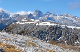
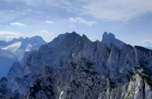
The views from the Scheichenspitze are among the most unforgettable - Sinabell and Eselstein to the east, Ennstal and the Schladming Tauern to the south, and the continuation of the ridge through Höhe Gamsfeldspitze and especially Der Dachstein to the west. The trident of Torstein, Mitterspitz and Hoher Dachstein reaches almost three thousand metres. The impressive panorama is rounded off in the north by Grosser Koppenkarstein and the view of the Dachsteinplateau, a random plateau on the NE side of the Dachsteinmassiv.
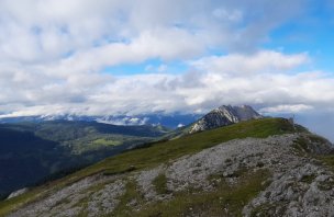
After a rest I descend the same way to the saddle and continue to Koppenkarstein. In the saddle of the Edelgrieβhöhe I look down in disbelief at the parachute and the descent stretching well 500 vertical metres below me. A steep shortcut with an easy ferrata turns off here, but I prefer to stick to the tourist route towards the edge of the Austria Scharte and the small glacier Edelgrieβ Gletscher. I descend to the glacier and cross over to the rock on the other side. In places there is frozen snow and blue ice in the middle, which melts quickly on a hot day. Streams of water run under my feet, it feels like the ice is moving, but it's an illusion. A steep descent leads down along the glacial stream. A few meters are secured with ropes and metal stupas, but nothing too difficult. And then further and further down between rocks and rubble fields. The next terrain break is already green, grassy and you can see a zig-zag descent from it to the lower station of the cable car-gondola station to Dachstein - Hunerkogel. From the cable car there is a shuttle bus to Ramsau. I continue under the wall down the Jungfrauensteig. The trident of the Dachstein can be seen here from a new perspective from the south. Next to it is the massive cone of the Rettenstein. The Jungfrauensteig is about an hour long, halfway up the weathered Jungfraeun rocks - fossilised maidens looking down into the valley. I can feel my feet at the bottom and am grateful for the straight path that leads me through the forest and between meadows back to the car (Ramsauer Panoramaweg).
Difficulty
A beautiful and varied trek starting on the mountain meadows, through the rocky alpine passages of the eastern part of the Dachstein massif, a short passage on a glacier and as a bonus interesting rock formations on the Jungfrauensteig descent to Ramsau. An alternative for ferratisti - the Ramsauer Höhenweg (Klettersteig) between Gruber Scharte and Edelgrieβhöhe (A-C), which follows the ridge. Or, conversely, save a few hundred vertical metres and a few kilometres by using the bus between Ramsau and the lower station of the Dachstein cable car. The total elevation gain is almost 2000 meters, so good fitness is necessary.
Water availability
There is a stream at the start of the route, refreshments are available at the Lärchbodenalm and Guttenbergerhaus.
Sleeping options
Accommodation is available at the Guttenbergerhaus or in the valley below the mountains.
Mountain peaks
Ascent to Scheichenspitze (2667 m), views "in order of appearance" Sinabell, Eselstein, Schladmingy, Gr. Koppenkarstein, Hoher Dachstein, Hohe Gamsfeldspitze, Dachstein - Krippenstein
Danger
The route is not dangerous, several secured sections. Tiefblicky deep into the valley can be a bit unnerving. A sure foot is needed in places and not to be afraid of heights :-)
Food
Takeaway food, refreshments at the start of the trail at the almo or the Guttenbergerhaus hut.
Attractions
Hoher Dachstein is 2995 m high and is the highest mountain in Upper Austria and Styria. Until the 19th century, however, the highest was believed to be Grimming (2351 m), about 30 km away. It was only after the measurements were refined that Dachstein gained its due tourist popularity as the highest mountain. Historical sources from the 19th century gave varying heights, sometimes as high as 3004 m, but this was more of a ploy to attract tourists. The summit cross of the Hoher Dachstein is 5 m high, so its peak is at exactly 3000.03 m. There are several glaciers on the Dachstein - the largest are on the north side - the Hallstadt, Schladming and Gosaugletscher. Unfortunately, the glaciers are melting rapidly due to climate change, and even their partial coverage does not help much. The Hoher Dachstein is accessible from several directions, the last metres are secured by klettersteig. The nearby Hunerkogel is reached by the Dachstein Südwandbahn (Dachstein Gondel).
Photos


